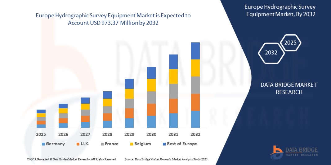
Europe Hydrographic Survey Equipment Market
Размер рынка в млрд долларов США
CAGR :
% 
 USD
658.34 Million
USD
973.37 Million
2024
2032
USD
658.34 Million
USD
973.37 Million
2024
2032
| 2025 –2032 | |
| USD 658.34 Million | |
| USD 973.37 Million | |
| % | |
Europe Hydrographic Survey Equipment Market Segmentation, Offering (Product and Software), Equipment Type (Pole Mounted and Portable and Compact) Depth (Shallow Water and Deep Water) Survey Type (General hydrographic Surveys, Coastal Surveys, Harbor Surveys, Passage Surveys, and Wreckage Surveys) Deployment (Manned Vessels, Unmanned Aerial Vehicles (UAVS), Unmanned Underwater Vehicles(UUVS), and Unmanned Surface Vehicles (USVS)) Application (Offshore Oil And Gas Survey, Hydrographic/ Bathymetric Survey, Cable/ Pipeline Route Survey, Port And Harbor Management, and Charting) End User (Defense, Commercial, and Research) – Industry Trends and Forecast to 2032
Hydrographic Survey Equipment Market Analysis
The Europe hydrographic survey equipment market has seen significant growth driven by advancements in technology and increasing demand for accurate water data across various industries. The market includes a wide range of products such as sonar systems, multi-beam and single-beam echo sounders, underwater drones, GPS systems, and data management software. Key applications span across marine navigation, environmental monitoring, coastal engineering, oil and gas exploration, and defense sectors. The rising need for precise mapping of underwater terrain, coupled with the growth in maritime trade, offshore activities, and environmental protection initiatives, continues to fuel market expansion. In addition, innovations such as automation, AI integration, and improved sensor technology are shaping the future of hydrographic surveys, making them more efficient and cost-effective.
Hydrographic Survey Equipment Market Size
Europe hydrographic survey equipment market size was valued at USD 658.34 million in 2024 and is projected to reach USD 973.37 million by 2032, with a CAGR of 5.2% during the forecast period of 2025 to 2032. In addition to the insights on market scenarios such as market value, growth rate, segmentation, geographical coverage, and major players, the market reports curated by the Data Bridge Market Research also include depth expert analysis, patient epidemiology, pipeline analysis, pricing analysis, and regulatory framework.
Hydrographic Survey Equipment Market Trends
“Expansion of Maritime Trade and Commerce”
The expansion of maritime trade and commerce is a key driver for the Europe hydrographic survey equipment market. As international shipping activities grow, the need for accurate and up-to-date marine data becomes crucial for safe navigation and efficient port operations. Hydrographic surveys help in mapping shipping lanes, identifying submerged hazards, and ensuring the safe passage of vessels, thereby supporting the smooth flow of goods across international waters. In addition, the increasing complexity of Europe trade routes and the need for sustainable port development require advanced survey technologies. This growing demand for precise data ensures the continued growth of the hydrographic survey equipment market. With expanding trade volumes, the market is positioned to witness increased investments in advanced surveying technologies. As such, hydrographic surveys play a vital role in sustaining the Europe maritime economy.
Report Scope and Hydrographic Survey Equipment Market Segmentation
|
Attributes |
Hydrographic Survey Equipment Key Market Insights |
|
Segments Covered |
|
|
Countries Covered |
Germany, U.K., France, Italy, Spain, Russia, Turkey, Netherlands, Norway, Finland, Denmark, Sweden, Poland, Switzerland, Belgium, and Rest of Europe |
|
Key Market Players |
Chesapeake Technology (U.S.), Esri Europe, Inc. (U.S.), South Surveying & Mapping Technology Co., Ltd (China), Trimble Applanix (Canada), Norbit Asa (Norway), Nortek Group (Norway), Beamworx (Netherlands), Ohmex Ltd (U.K.), R2Sonic, Inc. (U.S.), Syqwest (U.S.), Beijing Hydro-Tech Marine Technology Co., Ltd. (China), Kongsberg Discovery (Norway), Innomar Technologie GmbH (Germany), Teledyne Marine Technologies Incorporated (U.S.), EdgeTech (U.S.), Sonardyne (U.K.), ixblue (France), Tritech International Limited (U.K.), CEE HydroSystems (U.S.), Xylem (U.S.), Thales (France), Seafloor Systems, Inc. (U.S.),and ATLAS ELEKTRONIK GmbH (Germany) |
|
Market Opportunities |
|
|
Value Added Data Infosets |
In addition to the insights on market scenarios such as market value, growth rate, segmentation, geographical coverage, and major players, the market reports curated by the Data Bridge Market Research also include depth expert analysis, patient epidemiology, pipeline analysis, pricing analysis, and regulatory framework. |
Hydrographic Survey Equipment Market Definition
The hydrographic survey equipment refers to the industries focused on the production and sale of safety-related devices such as controllers, relays, switches, and various sensors. It is driven by increasing demand for automation, stricter safety regulations, and the need for efficient worker protection across industries such as automotive, oil & gas, food & beverage, and manufacturing. Safety sensors are devices used to monitor, detect, and respond to unsafe conditions in industrial environments to protect equipment, personnel, and processes. Safety controllers coordinate multiple safety inputs and outputs to trigger shutdowns or corrective actions. Safety relays isolate and switch circuits when risks are detected, ensuring systems operate safely. Safety switches monitor access points, stopping machinery when guards or doors are opened. Analog sensors provide continuous signals to measure variables such as pressure or temperature, while digital sensors offer discrete on/off signals. Smart sensors incorporate real-time monitoring, diagnostics, and predictive maintenance capabilities, enhancing automation and operational safety.
Hydrographic Survey Equipment Market Dynamics
Drivers
- Increasing Demand For Offshore Oil and Gas Exploration
The rising demand for offshore oil and gas exploration is accelerating the need for advanced hydrographic survey equipment to support precise underwater mapping and data collection. As companies explore deeper and more complex underwater environments, accurate bathymetric charts and seabed data become critical for identifying resource-rich areas, ensuring safe drilling operations, and minimizing environmental risks. This growing activity in offshore energy production is expected to fuel the adoption of state-of-the-art hydrographic technologies, including multibeam echo sounders, side-scan sonars, and ROV-mounted systems, within the Europe market.
For Instance:
In February 2024, a hydrographic survey was initiated at a wreckage site off Cove, Tobago, 21 days after a vessel spewing bunker fuel ran aground near the shoreline. The survey aimed to measure water depth and locate navigational hazards to facilitate the removal of the overturned barge while assessing the distribution of fuel and hydrocarbons. Specialists and advanced equipment were deployed for fuel containment and vessel recovery. This incident highlights the critical role of hydrographic survey equipment in offshore oil and gas operations, as it enables precise mapping, risk mitigation, and efficient disaster response, further driving demand in the Europe market
In October 2024, Turkey’s advanced oil research vessel, Oruc Reis, began Somalia’s first comprehensive offshore oil exploration program, covering 15,000 square kilometers across three blocks. Equipped with state-of-the-art hydrographic survey and seismic capabilities, the vessel will conduct geological, geophysical, and oceanographic studies over 5-7 months. This initiative, under a Turkey-Somalia partnership, underscores the growing demand for hydrographic survey equipment in offshore oil and gas exploration as countries seek advanced tools to unlock energy resources and drive economic growth in untapped regions
- Rise in Coastal Infrastructure Development
The rise in coastal infrastructure development is contributing to the drive of the Europe hydrographic survey equipment market, as accurate and detailed surveying of coastal areas is crucial for the planning and construction of infrastructure such as ports, harbors, and coastal defense systems. As these projects expand Europely, the demand for hydrographic survey equipment, including advanced sonar systems, mapping technologies, and environmental monitoring tools, is increasing. These technologies help assess water depths, seabed conditions, and potential environmental impacts, ensuring that coastal infrastructure projects are executed safely, efficiently, and sustainably.
For instance,
In October 2024, the Indian Navy received the second of four Survey Vessel (Large) ships, Nirdeshak (Yard 3026), built by Garden Reach Shipbuilders & Engineers (GRSE) in Kolkata. Nirdeshak is designed for comprehensive coastal and deep-water hydrographic surveys, which are essential for assessing port and harbor approaches and navigational channels and gathering oceanographic and geophysical data. The ship is equipped with advanced hydrographic technologies, including side scan sonar, DGPS positioning systems, and autonomous underwater vehicles. As coastal infrastructure development continues to rise Europely, the demand for such advanced survey vessels, such as Nirdeshak, highlights the growing need for accurate data collection and monitoring for safe, efficient infrastructure planning and development.
In April 2021, the Nigerian Navy's newest Offshore Survey Vessel, NNS LANA, made a port call at Las Palmas, Spain, on its homeward journey to Nigeria. This vessel, a replacement for the decommissioned NNS LANA, is equipped with state-of-the-art hydrographic, oceanographic, and geophysical survey equipment, including an electric propulsion system for minimal data distortion. Designed for hydrographic surveys and maritime security tasks, NNS LANA is a key asset for Nigeria’s maritime capabilities. The vessel’s advanced capabilities will enhance the nation's ability to conduct detailed surveys, supporting coastal infrastructure development. This growing demand for sophisticated survey vessels contributes to the rising need for hydrographic survey equipment Europely, particularly in coastal and offshore infrastructure projects.
Opportunities
- Technological Advancements In Survey Equipment
Technological advancements in survey equipment are significantly transforming the Europe hydrographic survey equipment market by enabling more accurate, efficient, and cost-effective data collection. Innovations such as Autonomous Underwater Vehicles (AUVs), Remotely Operated Vehicles (ROVs), multibeam sonar systems, and advanced positioning technologies have enhanced survey capabilities, allowing for detailed mapping of complex underwater environments. These developments are driving the adoption of more sophisticated equipment, which is crucial for monitoring and managing coastal infrastructure, marine environments, and navigation routes. As technology continues to evolve, the hydrographic survey equipment market is expected to expand, offering more reliable and sustainable solutions for a variety of applications, from maritime safety to environmental monitoring.
For instance,
In November 2020, IIT-Madras, a university in India, developed a solar-powered unmanned autonomous survey craft designed for hydrographic and oceanographic surveys in Indian ports and inland waterways. This innovative vessel, capable of operating both manually and autonomously, provides an indigenous alternative to costly foreign survey vessels. Equipped with echo sounders, GPS, and broadband communication, the craft can measure depth and underwater topography, transmitting real-time data over long distances. It also offers the potential to be fitted with additional sensors such as LiDAR for seamless topography and bathymetry. This technological advancement aligns with the increasing demand for cost-effective, efficient survey equipment in the Europe hydrographic survey equipment market, emphasizing the shift toward more autonomous, sustainable solutions that enhance survey accuracy, reduce operational costs, and enable better management of coastal infrastructure
- Integrating Hydrographic Survey Equipments with Predictive Maintenance Frameworks
As organizations embrace predictive maintenance to improve operational efficiency and reduce downtime, incorporating Hydrographic Survey Equipments into these frameworks presents enormous opportunities. Predictive maintenance uses real-time sensor data to predict equipment breakdowns before they occur, and introducing sensor cleaning methods into these systems can improve sensor performance and durability. This integration not only keeps sensors in top condition, but it also improves the whole value proposition of predictive maintenance programs, especially in businesses that rely on complex machinery and automated systems.For instance,
As per the MDPI article, by using vibration signals from cleaning robots, predictive maintenance frameworks can identify performance degradation and potential safety issues early. This allows for proactive intervention, preventing operational failures in autonomous mobile cleaning systems. The integration of predictive maintenance into sensor cleaning technologies offers a significant opportunity for growth, as it enhances system reliability and reduces downtime. As the demand for autonomous driving increases, sensor cleaning solutions with advanced monitoring capabilities will be essential to maintaining optimal sensor performance. This opens a new avenue for innovation and growth in the sensor cleaning market.
Restraints/Challenges
- Data Privacy and Security Concerns
Data privacy and security concerns present a significant challenge for the Europe hydrographic survey equipment market. As hydrographic surveys increasingly rely on digital systems, unmanned vehicles, and cloud-based data storage, the risk of cyberattacks and data breaches rises. Sensitive information, such as detailed seabed mapping and strategic maritime data, is vulnerable to unauthorized access or manipulation. Ensuring the protection of this data, especially in defense and security applications, requires robust cybersecurity measures and compliance with evolving data protection regulations. The complexity of securing these advanced technologies adds an additional layer of difficulty, particularly as the volume of data collected continues to grow.
For instance: -
In October 2024, according to the blog published by Balbix Inc., data privacy and security concerns have become a major challenge for IoT systems, which can be directly related to the Europe hydrographic survey equipment market. As hydrographic survey equipment increasingly integrates IoT devices, the same issues of weak security protocols, poor vulnerability testing, and unpatched software arise. Many devices lack robust security measures, leaving them vulnerable to cyberattacks. The vast amount of data generated by these systems, such as detailed seabed mapping, can also pose significant privacy risks if not properly safeguarded. These concerns complicate efforts to ensure secure data management and protection, highlighting the need for stronger security measures in hydrographic survey technologies.
- Limited Funding in Developing Regions
Limited funding in developing regions presents a significant challenge for the Europe hydrographic survey equipment market. Many countries in these regions struggle to allocate sufficient resources for advanced technologies such as hydrographic survey equipment, which are crucial for effective coastal management, infrastructure development, and environmental monitoring. This financial constraint hampers the adoption of modern equipment, limiting the ability to gather accurate data, make informed decisions, and support sustainable development efforts. As a result, these regions may fall behind in achieving reliable survey capabilities, impacting their overall growth and development.
For instance: -
In October 2023, according to the blog published by UNCTAD, the 46 Least Developed Countries (LDCs) faced severe financial challenges due to multiple Europe crises, growing debt, and dependence on volatile commodities. These financial constraints have significantly reduced their fiscal space, making it difficult to invest in critical infrastructure, including hydrographic survey equipment. Limited funding in these regions has hindered their ability to adopt modern technologies for effective environmental monitoring and infrastructure development. The financial squeeze, exacerbated by the climate emergency and Europe economic disruptions, presents a major obstacle to the growth of the hydrographic survey equipment market in these developing nations.
This market report provides details of new recent developments, trade regulations, import-export analysis, production analysis, value chain optimization, market share, impact of domestic and localized market players, analyses opportunities in terms of emerging revenue pockets, changes in market regulations, strategic market growth analysis, market size, category market growths, application niches and dominance, product approvals, product launches, geographic expansions, technological innovations in the market. To gain more info on the market contact Data Bridge Market Research for an Analyst Brief, our team will help you take an informed market decision to achieve market growth.
Hydrographic Survey Equipment Market Scope
The Europe hydrographic survey equipment market is segmented into seven notable segments based on the offering, equipment type, depth, survey type, deployment, application, and end user. The growth amongst these segments will help you analyze meagre growth segments in the industries and provide the users with a valuable market overview and market insights to help them make strategic decisions for identifying core market applications.
Offering
- Product
- Software
Equipment Type
- Pole Mounted
- Portable
- Compact
Depth
- Shallow Water
- Deep Water
Survey Type
- General hydrographic Surveys
- Coastal Surveys
- Harbor Surveys
- Passage Surveys
- Wreckage Surveys
Deployment
- Manned Vessels
- Unmanned Aerial Vehicles (UAVS)
- Unmanned Underwater Vehicles(UUVS)
- Unmanned Surface Vehicles (USVS))
Application
- Offshore Oil And Gas Survey
- Hydrographic/ Bathymetric Survey
- Cable/ Pipeline Route Survey
- Port And Harbor Management
- Charting
End User
- Defense
- Commercial
- Research
Hydrographic Survey Equipment Market Regional Analysis
The market is analyzed and market size insights and trends are provided by country, offering, equipment type, depth, survey type, deployment, application, and end user as referenced above.
The countries covered in the market are Germany, U.K., France, Italy, Spain, Russia, Turkey, Netherlands, Norway, Finland, Denmark, Sweden, Poland, Switzerland, Belgium, and rest of Europe.
U.K currently dominates the Europe hydrographic survey equipment market. This dominance is driven by the region's strong industrial base, particularly in sectors such as shipping , and manufacturing, where sensor reliability and performance are critical. Asia region has seen significant adoption of smart factory technologies and Industry 4.0 initiatives, driving demand for sensor cleaning solutions.
The country section of the report also provides individual market impacting factors and changes in regulation in the market domestically that impacts the current and future trends of the market. Data points such as down-stream and upstream value chain analysis, technical trends and porter's five forces analysis, case studies are some of the pointers used to forecast the market scenario for individual countries. Also, the presence and availability of Europe brands and their challenges faced due to large or scarce competition from local and domestic brands, impact of domestic tariffs and trade routes are considered while providing forecast analysis of the country data.
Hydrographic Survey Equipment Market Share
The market competitive landscape provides details by competitor. Details included are company overview, company financials, revenue generated, market potential, investment in research and development, new market initiatives, Europe presence, production sites and facilities, production capacities, company strengths and weaknesses, product launch, product width and breadth, application dominance. The above data points provided are only related to the companies' focus related to market.
Hydrographic Survey Equipment Market Leaders Operating in the Market Are:
- Chesapeake Technology (U.S.)
- Esri Europe, Inc. (U.S.)
- South Surveying & Mapping Technology Co., Ltd (China)
- Trimble Applanix (Canada)
- Norbit Asa (Norway)
- Nortek Group (Norway)
- Beamworx (Netherlands)
- Ohmex Ltd (U.K.)
- R2Sonic, Inc. (U.S.)
- Syqwest (U.S.)
- Beijing Hydro-Tech Marine Technology Co., Ltd. (China)
- Kongsberg Discovery (Norway)
- Innomar Technologie GmbH (Germany)
- Teledyne Marine Technologies Incorporated (U.S.)
- EdgeTech (U.S.)
- Sonardyne (U.K.)
- ixblue (France)
- Tritech International Limited (U.K.)
- CEE HydroSystems (U.S.)
- Xylem (U.S.)
- Thales (France)
- Seafloor Systems, Inc. (U.S.)
- ATLAS ELEKTRONIK GmbH (Germany)
Latest Developments in Europe Hydrographic Survey Equipment Market
- In September 2024, Teledyne Marine has named iOne Resources Inc. as its official distributor in the Philippines, expanding its footprint in Southeast Asia. This collaboration allows local customers to access Teledyne Marine's advanced hydrographic survey equipment, including high-resolution multibeam sonar systems, single-beam echo sounders, and robust data acquisition software, along with improved support and services
- In February 2024, Applanix has launched the POS MV series – Surfmaster, Wavemaster, and Oceanmaster – a complete inertial navigation system offering precise attitude, heading, heave, position, and velocity data for marine vessels and sensors. This advancement strengthens Applanix’s reputation as a leader in hydrographic survey equipment, providing highly reliable, accurate solutions that thrive in challenging marine environments, making it the preferred choice for professionals in the field
- In October 2023, ATLAS ELEKTRONIK and Israel Aerospace Industries unveiled the BlueWhale ASW platform for advanced anti-submarine warfare. An advanced autonomous underwater vehicle integrating ELTA’s sophisticated sensor systems and ATLAS ELEKTRONIK’s towed passive sonar array, designed for efficient submarine detection. This collaboration enhances both companies’ capabilities in naval defense, leveraging IAI’s expertise in unmanned systems and ELTA’s advanced sensor technologies, resulting in a state-of-the-art, long-endurance ASW solution suitable for various naval operations
- In March 2022, Xylem and UNICEF have deepened their partnership to tackle urgent water and sanitation challenges in the Horn of Africa, focusing on Ethiopia, Somalia, Sudan, and Uganda. This collaboration addresses climate-induced crises such as droughts and floods, aiming to enhance sustainable water and sanitation access through innovations such as solar-powered boreholes and capacity building for local utilities. The initiative strengthens Xylem’s commitment to water security, showcasing its expertise and social responsibility, while fostering brand credibility and driving sustainable solutions Europely
- In January 2022, Esri India has launched GeoInnovation 2022 in collaboration with AGNIi to support start-ups across sectors such as agriculture, healthcare, and smart cities by leveraging Location Intelligence technology. The program integrates Esri's GIS solutions into the start-up ecosystem, promoting innovation, particularly in hydrographic surveys. By incorporating geospatial data into industries such as offshore energy and maritime defense, Esri enhances its role in shaping the future of hydrographic survey solutions, fostering growth in this emerging market
SKU-
Получите онлайн-доступ к отчету на первой в мире облачной платформе рыночной аналитики
- Интерактивная панель анализа данных
- Панель анализа компании для возможностей с высоким потенциалом роста
- Доступ аналитика-исследователя для настройки и запросов
- Анализ конкурентов с помощью интерактивной панели
- Последние новости, обновления и анализ тенденций
- Используйте возможности сравнительного анализа для комплексного отслеживания конкурентов
Методология исследования
Сбор данных и анализ базового года выполняются с использованием модулей сбора данных с большими размерами выборки. Этап включает получение рыночной информации или связанных данных из различных источников и стратегий. Он включает изучение и планирование всех данных, полученных из прошлого заранее. Он также охватывает изучение несоответствий информации, наблюдаемых в различных источниках информации. Рыночные данные анализируются и оцениваются с использованием статистических и последовательных моделей рынка. Кроме того, анализ доли рынка и анализ ключевых тенденций являются основными факторами успеха в отчете о рынке. Чтобы узнать больше, пожалуйста, запросите звонок аналитика или оставьте свой запрос.
Ключевой методологией исследования, используемой исследовательской группой DBMR, является триангуляция данных, которая включает в себя интеллектуальный анализ данных, анализ влияния переменных данных на рынок и первичную (отраслевую экспертную) проверку. Модели данных включают сетку позиционирования поставщиков, анализ временной линии рынка, обзор рынка и руководство, сетку позиционирования компании, патентный анализ, анализ цен, анализ доли рынка компании, стандарты измерения, глобальный и региональный анализ и анализ доли поставщика. Чтобы узнать больше о методологии исследования, отправьте запрос, чтобы поговорить с нашими отраслевыми экспертами.
Доступна настройка
Data Bridge Market Research является лидером в области передовых формативных исследований. Мы гордимся тем, что предоставляем нашим существующим и новым клиентам данные и анализ, которые соответствуют и подходят их целям. Отчет можно настроить, включив в него анализ ценовых тенденций целевых брендов, понимание рынка для дополнительных стран (запросите список стран), данные о результатах клинических испытаний, обзор литературы, обновленный анализ рынка и продуктовой базы. Анализ рынка целевых конкурентов можно проанализировать от анализа на основе технологий до стратегий портфеля рынка. Мы можем добавить столько конкурентов, о которых вам нужны данные в нужном вам формате и стиле данных. Наша команда аналитиков также может предоставить вам данные в сырых файлах Excel, сводных таблицах (книга фактов) или помочь вам в создании презентаций из наборов данных, доступных в отчете.