Global Land Survey Equipment Market
Market Size in USD Billion
CAGR :
% 
 USD
9.87 Billion
USD
15.50 Billion
2025
2033
USD
9.87 Billion
USD
15.50 Billion
2025
2033
| 2026 –2033 | |
| USD 9.87 Billion | |
| USD 15.50 Billion | |
| % | |
|
What is the Global Land Survey Equipment Market Size and Growth Rate?
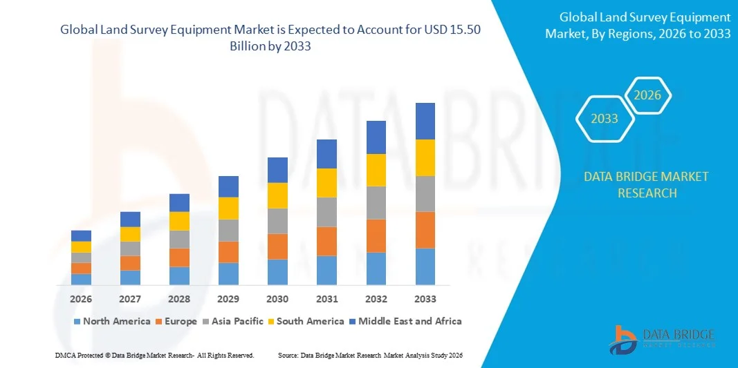
- The global land survey equipment market size was valued at USD 9.87 billion in 2025 and is expected to reach USD 15.50 billion by 2033, at a CAGR of 5.80% during the forecast period
- Increase in drone usage is a crucial factor accelerating the market growth, also rise in the advantage in time and accuracy, rise in the research and development activities in the market and increase in the demand for emerging economies are the major factors among others boosting the land survey equipment market
What are the Major Takeaways of Land Survey Equipment Market?
- Increase in the technological advancements and modernization in the production techniques will further create new opportunities for land survey equipment market in the forecast period mentioned above
- However, rise in the upgrading data management systems in surveys acts as the major factor among others restraining the market growth, and will further challenge the land survey equipment market in the forecast period mentioned above
- North America dominated the land survey equipment market with a 39.8% revenue share in 2025, driven by strong investments in infrastructure modernization, smart city projects, transportation development, and advanced geospatial technologies across the U.S. and Canada
- Asia-Pacific is projected to register the fastest CAGR of 8.39% from 2026 to 2033, driven by rapid urbanization, large-scale infrastructure development, smart city projects, and expanding transportation networks across China, Japan, India, South Korea, and Southeast Asia
- The GNSS Systems segment dominated the market with a 34.6% share in 2025, as these systems are widely used for high-precision positioning, real-time kinematic (RTK) surveying, and large-scale mapping projects
Report Scope and Land Survey Equipment Market Segmentation
|
Attributes |
Land Survey Equipment Key Market Insights |
|
Segments Covered |
|
|
Countries Covered |
North America
Europe
Asia-Pacific
Middle East and Africa
South America
|
|
Key Market Players |
|
|
Market Opportunities |
|
|
Value Added Data Infosets |
In addition to the insights on market scenarios such as market value, growth rate, segmentation, geographical coverage, and major players, the market reports curated by the Data Bridge Market Research also include in-depth expert analysis, pricing analysis, brand share analysis, consumer survey, demography analysis, supply chain analysis, value chain analysis, raw material/consumables overview, vendor selection criteria, PESTLE Analysis, Porter Analysis, and regulatory framework. |
What is the Key Trend in the Land Survey Equipment Market?
Growing Adoption of GNSS-Integrated, Drone-Compatible, and Digital Land Survey Equipment
- The land survey equipment market is witnessing strong adoption of GNSS-enabled total stations, RTK receivers, laser scanners, and drone-compatible surveying tools designed to improve accuracy, efficiency, and data collection speed in modern surveying projects
- Manufacturers are introducing high-precision GNSS systems, robotic total stations, and 3D laser scanning equipment that offer real-time positioning, automated measurements, and seamless integration with GIS and BIM platforms
- Growing demand for lightweight, portable, and digitally connected surveying equipment is driving adoption across construction, infrastructure development, mining, transportation planning, and environmental monitoring
- For instance, companies such as Trimble, Topcon, Leica Geosystems, and CHC Navigation are introducing advanced survey solutions with cloud-based data processing, AI-supported mapping, and drone integration capabilities
- Increasing need for high-speed data capture, remote site monitoring, and real-time geospatial analysis is accelerating the shift toward smart and automated land surveying technologies
- As urbanization, smart city projects, and infrastructure investments expand globally, Land Survey Equipment will remain essential for accurate mapping, geospatial analysis, and efficient project planning
What are the Key Drivers of Land Survey Equipment Market?
- Rising demand for high-accuracy surveying tools to support large-scale infrastructure projects, urban planning, transportation development, and construction activities
- For instance, in 2025, companies such as Trimble, Topcon, and CHC Navigation launched advanced GNSS receivers, robotic total stations, and mobile mapping systems designed to improve positioning accuracy and surveying productivity
- Growing adoption of smart cities, highway construction, rail projects, renewable energy installations, and mining exploration is boosting demand for precision land measurement and mapping solutions across the U.S., Europe, and Asia-Pacific
- Advancements in satellite positioning technology, LiDAR scanning, automated surveying software, and drone-based mapping platforms have improved data accuracy, speed, and operational efficiency
- Rising use of geospatial data analytics, GIS platforms, and digital terrain modeling is creating demand for high-performance surveying instruments capable of capturing large-scale spatial datasets
- Supported by increasing investments in infrastructure modernization, geospatial intelligence, and digital construction technologies, the Land Survey Equipment market is expected to witness steady long-term growth
Which Factor is Challenging the Growth of the Land Survey Equipment Market?
- High acquisition and maintenance costs associated with advanced GNSS systems, robotic total stations, and 3D laser scanners limit adoption among small surveying firms and contractors
- For instance, during 2024–2025, fluctuations in electronic component costs, precision sensor prices, and satellite technology integration increased manufacturing expenses for several global equipment providers
- Complexity in operating high-precision surveying instruments, LiDAR mapping systems, and GNSS-based positioning technologies increases the need for skilled professionals and specialized training
- Limited awareness regarding advanced surveying technologies and digital mapping tools in some developing regions slows equipment adoption and modernization
- Competition from drone-based photogrammetry, satellite imagery platforms, and low-cost mapping software solutions creates pricing pressure and affects equipment sales
- To address these challenges, companies are focusing on cost-efficient instruments, cloud-based surveying platforms, training programs, and integrated software ecosystems to expand global adoption of Land Survey Equipment
How is the Land Survey Equipment Market Segmented?
The market is segmented on the basis of product, industry, and application.
- By Product
On the basis of product, the land survey equipment market is segmented into GNSS Systems, Total Stations & Theodolites, Levels, 3D Laser/Laser Scanners, Unmanned Aerial Vehicles (UAVs), and Others. The GNSS Systems segment dominated the market with a 34.6% share in 2025, as these systems are widely used for high-precision positioning, real-time kinematic (RTK) surveying, and large-scale mapping projects. GNSS equipment enables accurate geospatial data collection, faster field measurements, and efficient surveying operations, making it highly valuable across construction, infrastructure development, agriculture mapping, and land management. Continuous advancements in multi-constellation satellite support, real-time data processing, and integrated GIS compatibility further strengthen the adoption of GNSS solutions in modern surveying projects.
The Unmanned Aerial Vehicles (UAVs) segment is expected to grow at the fastest CAGR from 2026 to 2033, driven by increasing adoption of drone-based photogrammetry, aerial mapping, and remote terrain surveying. UAVs significantly reduce survey time, improve accessibility in difficult terrains, and provide high-resolution imaging and rapid topographic data collection, supporting their growing use in infrastructure inspection, mining exploration, and environmental monitoring.
- By Industry
On the basis of industry, the land survey equipment market is segmented into Construction, Oil & Gas, Agriculture, Mining, Disaster Management, and Others. The Construction segment dominated the market with a 41.2% share in 2025, supported by increasing urbanization, infrastructure development, and large-scale transportation projects worldwide. Land survey equipment plays a crucial role in site mapping, boundary identification, terrain modeling, and structural layout planning for residential, commercial, and industrial developments. Technologies such as GNSS receivers, robotic total stations, and laser scanners help engineers and contractors achieve accurate site measurements, improved project planning, and reduced construction errors, making surveying tools indispensable across modern construction workflows.
The Mining segment is expected to grow at the fastest CAGR from 2026 to 2033, driven by rising demand for mineral exploration, resource estimation, and mine site monitoring. Advanced surveying technologies such as drone-based mapping, LiDAR scanning, and GNSS positioning systems enable mining companies to perform precise volumetric analysis, terrain monitoring, and operational planning, thereby improving productivity and safety across global mining operations.
- By Application
On the basis of application, the land survey equipment market is segmented into Inspection & Monitoring, Volumetric Calculations, and Layout Points. The Layout Points segment dominated the market with a 38.7% share in 2025, as it is essential for accurate placement of infrastructure elements such as buildings, roads, bridges, pipelines, and utility networks. Surveying instruments including total stations, GNSS systems, and levels are widely used to determine precise coordinates, elevations, and alignment points during construction and infrastructure development. The increasing number of urban infrastructure projects, smart city initiatives, and transportation networks is further driving demand for reliable layout surveying solutions.
The Inspection & Monitoring segment is expected to grow at the fastest CAGR from 2026 to 2033, driven by rising demand for structural monitoring, land deformation analysis, and infrastructure safety inspections. Technologies such as 3D laser scanning, UAV mapping, and automated GNSS monitoring systems enable continuous data collection and real-time analysis, supporting improved asset management, disaster risk assessment, and long-term infrastructure maintenance.
Which Region Holds the Largest Share of the Land Survey Equipment Market?
- North America dominated the land survey equipment market with a 39.8% revenue share in 2025, driven by strong investments in infrastructure modernization, smart city projects, transportation development, and advanced geospatial technologies across the U.S. and Canada. Increasing adoption of GNSS receivers, robotic total stations, UAV mapping systems, and 3D laser scanners supports accurate land measurement, site planning, and large-scale mapping applications across construction, mining, and environmental monitoring projects
- Leading companies in the region are introducing high-precision surveying instruments integrated with cloud-based mapping software, real-time data processing, and advanced GIS compatibility, strengthening North America’s technological leadership in modern geospatial solutions
- Strong presence of geospatial technology firms, engineering companies, and advanced surveying service providers, combined with sustained investments in transportation infrastructure, renewable energy projects, and urban development, continues to reinforce regional market dominance
U.S. Land Survey Equipment Market Insight
The U.S. represents the largest contributor in North America, supported by extensive infrastructure development, highway construction, renewable energy projects, and urban planning initiatives. Surveying equipment such as GNSS systems, robotic total stations, and LiDAR scanners are widely used for construction layout, topographic mapping, land management, and infrastructure monitoring. Increasing adoption of drone-based mapping, automated surveying technologies, and digital terrain modeling is improving operational efficiency and data accuracy. Strong presence of geospatial technology providers, construction engineering firms, and advanced surveying service companies, along with continuous investment in smart infrastructure and digital construction tools, further supports market growth across the country.
Canada Land Survey Equipment Market Insight
Canada contributes significantly to regional growth, driven by rising demand for geospatial data, land management solutions, and infrastructure mapping across sectors such as transportation, mining, forestry, and environmental monitoring. Surveying technologies including GNSS receivers, UAV mapping systems, and 3D laser scanners are widely used for terrain analysis, pipeline planning, and natural resource exploration. Government-backed initiatives promoting digital mapping, land surveying modernization, and infrastructure expansion further strengthen equipment adoption. In addition, the country’s strong mining industry, growing renewable energy installations, and expanding geospatial technology ecosystem continue to support steady demand for advanced land surveying instruments.
Asia-Pacific Land Survey Equipment Market
Asia-Pacific is projected to register the fastest CAGR of 8.39% from 2026 to 2033, driven by rapid urbanization, large-scale infrastructure development, smart city projects, and expanding transportation networks across China, Japan, India, South Korea, and Southeast Asia. Increasing adoption of GNSS surveying systems, drone-based mapping, LiDAR scanning, and digital surveying software is improving efficiency in construction, mining, agriculture, and disaster management activities. Growth in railway expansion, highway construction, renewable energy installations, and industrial development continues to accelerate demand for accurate geospatial measurement technologies. In addition, rising investments in geospatial intelligence, digital construction platforms, and automated surveying equipment are strengthening regional market expansion.
China Land Survey Equipment Market Insight
China is the largest contributor to the Asia-Pacific market due to massive investments in infrastructure construction, transportation development, and smart city projects. The country’s strong manufacturing base and large-scale highway, railway, and urban development projects drive demand for high-precision GNSS receivers, robotic total stations, and UAV mapping systems. Rapid expansion of drone-based surveying, LiDAR mapping, and digital terrain modeling technologies further enhances data collection efficiency. Government initiatives supporting geospatial mapping, land resource management, and digital infrastructure planning also strengthen the adoption of advanced land survey equipment across the country.
Japan Land Survey Equipment Market Insight
Japan demonstrates steady growth supported by advanced construction engineering capabilities, infrastructure modernization projects, and precision mapping technologies. The country widely adopts high-accuracy surveying instruments, robotic total stations, and 3D laser scanners for urban development, transportation planning, and disaster risk management. Strong emphasis on precision engineering, automation, and high-quality surveying standards encourages the adoption of technologically advanced equipment. In addition, the need for accurate terrain monitoring, earthquake risk assessment, and infrastructure inspection supports continuous demand for modern land surveying solutions in Japan.
India Land Survey Equipment Market Insight
India is emerging as a significant growth hub due to increasing infrastructure development, smart city initiatives, and government-backed digital land mapping programs. Expanding highway networks, railway modernization, renewable energy projects, and urban construction activities are boosting demand for GNSS surveying systems, total stations, and drone-based mapping solutions. Government initiatives such as digital land record modernization and geospatial data accessibility reforms are improving the adoption of advanced surveying technologies. Rising investments in construction engineering, mining exploration, and digital mapping infrastructure are further accelerating the penetration of land survey equipment across the country.
South Korea Land Survey Equipment Market Insight
South Korea contributes significantly to regional growth due to strong demand for smart infrastructure development, advanced construction technologies, and geospatial data analytics. Surveying instruments such as GNSS receivers, UAV mapping systems, and LiDAR scanners are increasingly used for urban planning, transportation infrastructure, and industrial site development. The country’s focus on digital construction technologies, smart city development, and automated mapping solutions supports adoption of high-precision surveying equipment. In addition, continuous investment in technology innovation, infrastructure monitoring systems, and geospatial intelligence platforms strengthens long-term market expansion.
Which are the Top Companies in Land Survey Equipment Market?
The land survey equipment industry is primarily led by well-established companies, including:
- Hi-Target Navigation Technology Corporation (China)
- Hudaco Industries Limited (South Africa)
- Kolida Instrument Co., Ltd. (China)
- Robert Bosch GmbH (Germany)
- Shanghai Huace Navigation Technology Ltd. (CHC Navigation) (China)
- Stonex (Italy)
- Suzhou Foif Co., Ltd. (China)
- Topcon Corporation (Japan)
- Trimble Inc (U.S.)
What are the Recent Developments in Global Land Survey Equipment Market?
- In June 2025, Harper Surveying LLC announced the expansion of its construction service capabilities through the deployment of advanced 3D laser scanning technologies. The company selected high-end scanning solutions from FARO, Leica, Trimble, and Artec due to their strong interoperability, precision, and ease of integration with modern surveying workflows. These systems enable Harper Surveying to generate high-density, real-time spatial data, significantly improving the accuracy of as-built documentation and enhancing the integration of data into existing Building Information Modeling (BIM) processes. This development highlights the growing importance of advanced scanning technologies in modern construction surveying and digital project management
- In May 2024, a collaborative project aimed at evaluating the condition of the Ogallala Aquifer initiated aerial electromagnetic surveys across northwest Kansas during late May through early June. The Kansas Geological Survey at the University of Kansas participated as a key partner in the initiative, providing technical expertise and research support. The survey program focuses on collecting geophysical data to better understand groundwater availability and aquifer conditions across the region. This initiative demonstrates how advanced surveying technologies are increasingly being used for environmental monitoring and sustainable resource management
- In May 2024, a scientist from the Hawaiian Volcano Observatory (HVO) installed temporary GPS surveying equipment south of Kaluapele, with the extensive profile of Mauna Loa volcano visible in the background. The equipment was deployed to capture high-precision geospatial data that helps researchers monitor volcanic activity and ground deformation. By analyzing data gathered from both current observations and past eruptions, scientists are gaining deeper insights into the cyclic patterns and behavioral characteristics of volcanic systems. This effort underscores the critical role of advanced land surveying technologies in geological monitoring and disaster risk assessment
- In February 2024, John Deere and Leica Geosystems announced a strategic partnership focused on accelerating digital transformation within the heavy construction industry. The collaboration combines John Deere’s manufacturing expertise with Leica Geosystems’ advanced positioning, measurement, and sensor technologies to develop solutions that enhance operational productivity and reduce material costs on construction sites. The partnership aims to introduce innovative machine control and surveying solutions that support more efficient project execution. This strategic alliance highlights the growing integration of surveying technology with construction equipment to improve efficiency and precision in infrastructure development
SKU-
Get online access to the report on the World's First Market Intelligence Cloud
- Interactive Data Analysis Dashboard
- Company Analysis Dashboard for high growth potential opportunities
- Research Analyst Access for customization & queries
- Competitor Analysis with Interactive dashboard
- Latest News, Updates & Trend analysis
- Harness the Power of Benchmark Analysis for Comprehensive Competitor Tracking
Global Land Survey Equipment Market, Supply Chain Analysis and Ecosystem Framework
To support market growth and help clients navigate the impact of geopolitical shifts, DBMR has integrated in-depth supply chain analysis into its Global Land Survey Equipment Market research reports. This addition empowers clients to respond effectively to global changes affecting their industries. The supply chain analysis section includes detailed insights such as Global Land Survey Equipment Market consumption and production by country, price trend analysis, the impact of tariffs and geopolitical developments, and import and export trends by country and HSN code. It also highlights major suppliers with data on production capacity and company profiles, as well as key importers and exporters. In addition to research, DBMR offers specialized supply chain consulting services backed by over a decade of experience, providing solutions like supplier discovery, supplier risk assessment, price trend analysis, impact evaluation of inflation and trade route changes, and comprehensive market trend analysis.
Research Methodology
Data collection and base year analysis are done using data collection modules with large sample sizes. The stage includes obtaining market information or related data through various sources and strategies. It includes examining and planning all the data acquired from the past in advance. It likewise envelops the examination of information inconsistencies seen across different information sources. The market data is analysed and estimated using market statistical and coherent models. Also, market share analysis and key trend analysis are the major success factors in the market report. To know more, please request an analyst call or drop down your inquiry.
The key research methodology used by DBMR research team is data triangulation which involves data mining, analysis of the impact of data variables on the market and primary (industry expert) validation. Data models include Vendor Positioning Grid, Market Time Line Analysis, Market Overview and Guide, Company Positioning Grid, Patent Analysis, Pricing Analysis, Company Market Share Analysis, Standards of Measurement, Global versus Regional and Vendor Share Analysis. To know more about the research methodology, drop in an inquiry to speak to our industry experts.
Customization Available
Data Bridge Market Research is a leader in advanced formative research. We take pride in servicing our existing and new customers with data and analysis that match and suits their goal. The report can be customized to include price trend analysis of target brands understanding the market for additional countries (ask for the list of countries), clinical trial results data, literature review, refurbished market and product base analysis. Market analysis of target competitors can be analyzed from technology-based analysis to market portfolio strategies. We can add as many competitors that you require data about in the format and data style you are looking for. Our team of analysts can also provide you data in crude raw excel files pivot tables (Fact book) or can assist you in creating presentations from the data sets available in the report.