Photogrammetry software is a powerful tool that enables precise 3D modeling and mapping. Analyzing aerial or ground-based imagery, the software extracts measurements and reconstructs objects, environments, and terrain in a digital format. It utilizes advanced algorithms and techniques to ensure an accurate representation of physical spaces and objects. This software finds applications in industries such as architecture, construction, surveying, and virtual reality, empowering professionals to create detailed and realistic 3D models and maps with unparalleled accuracy and precision.
Access Full Report at https://www.databridgemarketresearch.com/reports/global-photogrammetry-software-market
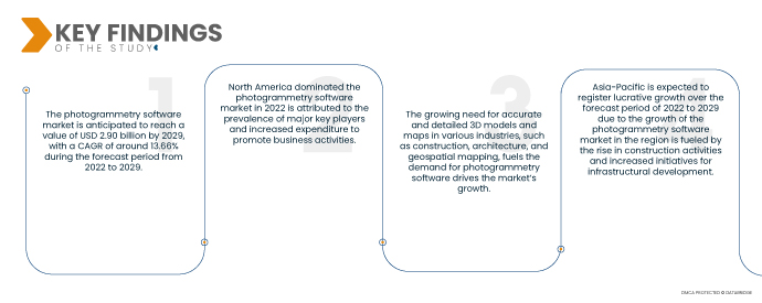
Data Bridge Market Research analyses that the Photogrammetry Software Market is valued at USD 1.04 billion in 2021 and is expected to reach USD 2.90 billion by 2029, registering a CAGR of 13.66% during the forecast period of 2022 to 2029. The availability of high-resolution aerial and satellite imagery has expanded the applications of photogrammetry software, driving its adoption in fields like urban planning, environmental monitoring, and land surveying boosting the market’s growth.
Key Findings of the Study
The rise in drone usage is expected to drive the market's growth rate
The rising popularity of drones equipped with high-quality cameras has revolutionized the field of aerial imagery and data collection for photogrammetry. Drones provide a cost-effective and efficient solution for capturing precise aerial images, allowing for the creation of accurate 3D models and maps. Industries such as construction, agriculture, mining, and surveying have embraced the use of drones for data collection, which has significantly increased the demand for photogrammetry software to process and analyze the captured images and generate actionable insights.
Report Scope and Market Segmentation
Report Metric
|
Details
|
Forecast Period
|
2022 to 2029
|
Base Year
|
2021
|
Historic Years
|
2020 (Customizable to 2014-2019)
|
Quantitative Units
|
Revenue in USD Billion, Volumes in Units, Pricing in USD
|
Segments Covered
|
Method (Aerial Photogrammetry, Terrestrial (Close Range) Photogrammetry, Satellite Photogrammetry, Macro Photogrammetry), Photogrammetry Style (Point-and-Shoot Photogrammetry, Multi-Camera Photogrammetry and Video-to-Photogrammetry), Application (Culture Heritage and Museum, Films and Games, Topographic Maps, Traffic Management System, 3D Printing, Drones and Robots, Others), End User (Building and Construction, Automotive, Energy, Oil and Gas, Ship Building, Others)
|
Countries Covered
|
U.S., Canada and Mexico in North America, Germany, France, U.K., Netherlands, Switzerland, Belgium, Russia, Italy, Spain, Turkey, Rest of Europe in Europe, China, Japan, India, South Korea, Singapore, Malaysia, Australia, Thailand, Indonesia, Philippines, Rest of Asia-Pacific (APAC) in the Asia-Pacific (APAC), Saudi Arabia, U.A.E, South Africa, Egypt, Israel, Rest of Middle East and Africa (MEA) as a part of Middle East and Africa (MEA), Brazil, Argentina and Rest of South America as part of South America.
|
Market Players Covered
|
Pix4D SA (Switzerland), 3Dflow SR (Italy), Agisoft (Russia), Capturing Reality s.r.o. (Slovakia), Vexcel Imaging GmbH (Austria), nFrames (Germany), REDcatch GmbH (Austria), NUBIGON Inc. (U.S.), Linearis3D GmbH & Co.KG (Germany), Menci software SRL (Italy), Photometrix Photogrammetry Software (Australia), Skyline Software Systems Inc. (U.S.), Racurs (Moscow), SimActive Inc. (Canada), ICAROS (Germany), Magnasoft. (India), DroneDeploy (U.S.), PhotoModeler Technologies (Canada), Esri International LLC (U.S.), Autodesk, Inc. (U.S.), Trimble Inc. (U.S.), and Hexagon AB (Sweden), among others
|
Data Points Covered in the Report
|
In addition to the insights on market scenarios such as market value, growth rate, segmentation, geographical coverage, and major players, the market reports curated by the Data Bridge Market Research also include depth expert analysis, patient epidemiology, pipeline analysis, pricing analysis, and regulatory framework
|
Segment Analysis:
The photogrammetry software market is segmented on the basis of method, photogrammetry style, application and end user.
- On the basis of method, the market is segmented into aerial photogrammetry, terrestrial (close range) photogrammetry, satellite photogrammetry, and macro photogrammetry.
- On the basis of photogrammetry style, the market is segmented into point-and-shoot photogrammetry, multi-camera photogrammetry, and video-to-photogrammetry.
- On the basis of application the market is segmented into culture heritage and museum, films and games, topographic maps, traffic management system, 3D printing, drones and robots, and others.
- On the basis of end user the market is segmented into building and construction, automotive, energy, oil and gas, ship building, and others.
Major Players
Data Bridge Market Research recognizes the following companies as the major photogrammetry software market players in photogrammetry software market are Pix4D SA (Switzerland), 3Dflow SR (Italy), Agisoft (Russia), Capturing Reality s.r.o. (Slovakia), Vexcel Imaging GmbH (Austria), nFrames (Germany), REDcatch GmbH (Austria)
Market Developments
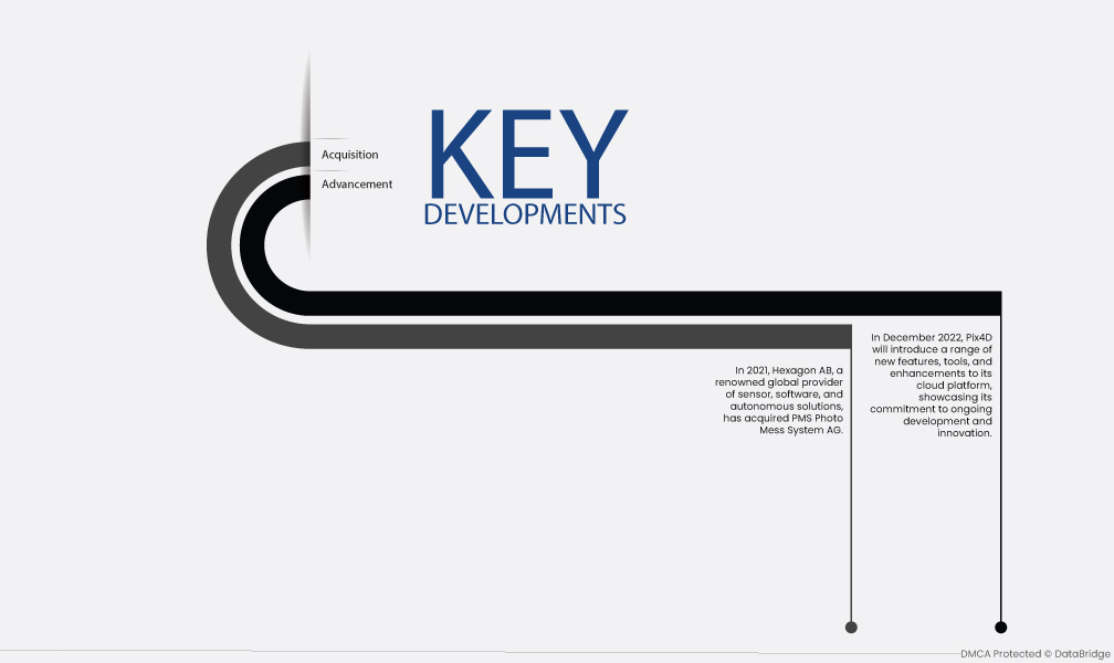
- In December 2022, Pix4D will introduce a range of new features, tools, and enhancements to its cloud platform, showcasing its commitment to ongoing development and innovation. Users can anticipate exciting updates that will enhance their experience and provide expanded capabilities for processing and analyzing aerial imagery and data.
- In 2021, Hexagon AB, a renowned global provider of sensor, software, and autonomous solutions, has acquired PMS Photo Mess System AG. This strategic acquisition is set to bolster PMS's presence in the competitive photogrammetry software market.
Regional Analysis
Geographically, the countries covered in the photogrammetry software market report are U.S., Canada and Mexico in North America, Germany, France, U.K., Netherlands, Switzerland, Belgium, Russia, Italy, Spain, Turkey, Rest of Europe in Europe, China, Japan, India, South Korea, Singapore, Malaysia, Australia, Thailand, Indonesia, Philippines, Rest of Asia-Pacific (APAC) in the Asia-Pacific (APAC), Saudi Arabia, U.A.E, South Africa, Egypt, Israel, Rest of Middle East and Africa (MEA) as a part of Middle East and Africa (MEA), Brazil, Argentina and Rest of South America as part of South America.
As per Data Bridge Market Research analysis:
North America is the dominant region in the photogrammetry software market during the forecast period 2022 - 2029
In 2022, North America dominated the photogrammetry software market due the presence of established software providers with extensive product portfolios and strong market presence drives competition and innovation. Additionally, increased investments in marketing and promotional efforts by companies and industry stakeholders create awareness and drive demand for photogrammetry software solutions. This combination of established market players and strategic investments fosters market growth, expanding the adoption of photogrammetry software across various industries in the region.
Asia-Pacific is estimated to be the fastest growing region in the global light detection and ranging (LiDAR) market for the forecast period 2022 - 2029
Asia-Pacific is expected to grow during the forecast period as the region witnesses a surge in construction projects, and the demand for accurate 3D modeling and mapping solutions provided by photogrammetry software increases. Governments and organizations are investing in infrastructure development, such as roads, buildings, and urban planning, creating opportunities for the application of photogrammetry software.
For more detailed information about the photogrammetry software market report, click here – https://www.databridgemarketresearch.com/reports/global-photogrammetry-software-market
