تُعدّ الخرائط الرقمية حجر الأساس للخدمات القائمة على الموقع (LBS)، إذ تُوفّر البيانات المكانية الأساسية اللازمة للتطبيقات المُخصّصة والواعية للسياق. ومن خلال الاستفادة من المعلومات الجغرافية الدقيقة، يُمكن لتطبيقات LBS أن تُقدّم للمستخدمين خدمات مُصمّمة خصيصًا لهم، مثل توصيات المطاعم، وتحديثات الطقس الفورية، وعمليات بحث فعّالة عن الشركات المحلية. ويُحسّن دمج الخرائط الرقمية تجارب المستخدم من خلال توفير معلومات مُحدّدة الموقع، مما يُعزّز راحته وفعاليته. وسواءً كان المستخدم يتنقل بين المدن أو يستكشف مناطق جديدة، فإنّ الاعتماد على الخرائط الرقمية يضمن قدرة تطبيقات LBS على توفير معلومات دقيقة وفي الوقت المناسب، مما يُتيح له رحلة سلسة ومُخصّصة بناءً على سياقه الجغرافي.
يمكنك الوصول إلى التقرير الكامل على https://www.databridgemarketresearch.com/reports/south-east-asia-digital-map-market
تشير تحليلات شركة داتا بريدج لأبحاث السوق إلى أنه من المتوقع أن يصل سوق الخرائط الرقمية في جنوب شرق آسيا إلى 43,953.78 مليون دولار أمريكي بحلول عام 2030، و1,214.35 مليون دولار أمريكي في عام 2022، بمعدل نمو سنوي مركب قدره 15.90% بين عامي 2023 و2030. يجذب النمو الاقتصادي القوي في جنوب شرق آسيا الاستثمارات ويحفز توسع الأعمال. إن الاعتماد المتزايد على الخرائط الرقمية داخل الشركات لتحليل السوق وتحديد مواقع العملاء وتحسين سلسلة التوريد يجعل سوق الخرائط الرقمية في جنوب شرق آسيا محركًا رئيسيًا، وهو أمر حيوي لتعزيز التنمية الاقتصادية في جميع أنحاء المنطقة.
النتائج الرئيسية للدراسة
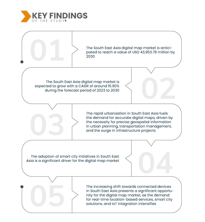
ومن المتوقع أن تؤدي المبادرات واللوائح الحكومية المتزايدة إلى دفع معدل نمو السوق
تُعدّ المبادرات واللوائح الحكومية في جنوب شرق آسيا محركات رئيسية لسوق الخرائط الرقمية. وإدراكًا منها لأهمية التكنولوجيا الجغرافية المكانية، تُطبّق الحكومات الإقليمية سياسات ولوائح تُعزّز استخدام الخرائط الرقمية في التخطيط الحضري وإدارة الكوارث والرصد البيئي. تُهيئ هذه المبادرات بيئةً مُواتيةً للشركات والقطاعات للاستفادة من حلول رسم الخرائط الرقمية. كما تُشجّع الأطر الحكومية الداعمة الاستثمار في التقنيات المتقدمة، مثل الذكاء الاصطناعي وإنترنت الأشياء، مما يُعزّز قدرات الخرائط الرقمية.
نطاق التقرير وتقسيم السوق
مقياس التقرير
|
تفاصيل
|
فترة التنبؤ
|
من 2023 إلى 2030
|
سنة الأساس
|
2022
|
السنوات التاريخية
|
2021 (قابلة للتخصيص حتى 2015 - 2020)
|
الوحدات الكمية
|
الإيرادات بالملايين من الدولارات الأمريكية، والحجم بالوحدات، والتسعير بالدولار الأمريكي
|
القطاعات المغطاة
|
المكون (البرمجيات، الحلول، الخدمات)، الوظائف (علمية، ملاحة GPS، محوسبة)، التطبيق (التوجيه والملاحة، تتبع الأصول، الترميز الجغرافي وتحديد المواقع الجغرافية، تخطيط الشبكة، مسح الأراضي، التفتيش)، وضع العرض (عرض الخطة ثنائية الأبعاد، منظور ثلاثي الأبعاد)، نموذج النشر (محلي، سحابي)، نوع الخريطة (ثابت، ديناميكي)، التكنولوجيا ( نظام المعلومات الجغرافية ، كشف الضوء وتحديد المدى، التصوير الجوي، التصوير الرقمي)، المستخدم النهائي (الملاحة/تحديد المواقع الداخلية، الخارجية)
|
الدول المغطاة
|
سنغافورة، ماليزيا، تايلاند، الفلبين، إندونيسيا، فيتنام، بورما (ميانمار)، كمبوديا، بروناي، لاوس، بقية دول جنوب شرق آسيا
|
الجهات الفاعلة في السوق المغطاة
|
Google LLC (الولايات المتحدة)، TomTom International BV (هولندا)، Maxar Technologies (الولايات المتحدة)، Apple, Inc. (الولايات المتحدة)، HERE (هولندا)، Esri (الولايات المتحدة)، Getmapping plc (المملكة المتحدة)، Intermap Technologies (الولايات المتحدة)، MiTAC Holdings Corp. (تايوان)، Nearmap (الولايات المتحدة)، MAPQUEST (الولايات المتحدة)، ThinkGeo LLC (الولايات المتحدة)، DMTI Spatial (كندا)، Lepton Software (الولايات المتحدة)، L3Harris Technologies Inc. (الولايات المتحدة)، PASCO Philippines Corporation (الولايات المتحدة)، Skymap Global (سنغافورة)
|
نقاط البيانات التي يغطيها التقرير
|
بالإضافة إلى رؤى السوق مثل القيمة السوقية ومعدل النمو وشرائح السوق والتغطية الجغرافية واللاعبين في السوق وسيناريو السوق، فإن تقرير السوق الذي أعده فريق أبحاث السوق في Data Bridge يتضمن تحليلًا متعمقًا من الخبراء وتحليل الاستيراد / التصدير وتحليل التسعير وتحليل استهلاك الإنتاج وتحليل المدقة.
|
تحليل القطاعات:
يتم تقسيم سوق الخرائط الرقمية في جنوب شرق آسيا على أساس المكون والوظيفة والتطبيق ووضع العرض ونموذج النشر ونوع الخريطة والتكنولوجيا والمستخدم النهائي.
- على أساس المكون، يتم تقسيم سوق الخرائط الرقمية في جنوب شرق آسيا إلى برمجيات وحلول وخدمات
- على أساس الوظيفة، يتم تقسيم سوق الخرائط الرقمية في جنوب شرق آسيا إلى خرائط علمية وملاحة GPS وخرائط محوسبة
- على أساس التطبيق، يتم تقسيم سوق الخرائط الرقمية في جنوب شرق آسيا إلى التوجيه والملاحة، وتتبع الأصول، والترميز الجغرافي وتحديد المواقع الجغرافية، وتخطيط الشبكات، ومسح الأراضي، والتفتيش
- على أساس وضع العرض، يتم تقسيم سوق الخرائط الرقمية في جنوب شرق آسيا إلى عرض مخطط ثنائي الأبعاد ومنظور ثلاثي الأبعاد
- على أساس نموذج النشر، يتم تقسيم سوق الخرائط الرقمية في جنوب شرق آسيا إلى محلي وسحابي
- على أساس نوع الخريطة، يتم تقسيم سوق الخرائط الرقمية في جنوب شرق آسيا إلى ثابتة وديناميكية
- على أساس التكنولوجيا، يتم تقسيم سوق الخرائط الرقمية في جنوب شرق آسيا إلى نظام المعلومات الجغرافية، وكشف الضوء وتحديد المدى، والتصوير الجوي، والتصوير الجوي الرقمي.
- على أساس المستخدم النهائي، يتم تقسيم سوق الخرائط الرقمية في جنوب شرق آسيا إلى الملاحة/التحديد الداخلي، والخرائط الخارجية
اللاعبون الرئيسيون
تعترف شركة Data Bridge Market Research بالشركات التالية باعتبارها اللاعبين الرئيسيين في سوق الخرائط الرقمية في جنوب شرق آسيا وهي Google LLC (الولايات المتحدة)، و TomTom International BV (هولندا)، و Maxar Technologies (الولايات المتحدة)، و Apple، Inc. (الولايات المتحدة)، و HERE (هولندا)، و Esri (الولايات المتحدة)، و Getmapping plc (المملكة المتحدة)، و Intermap Technologies (الولايات المتحدة)، و MiTAC Holdings Corp. (تايوان)، و Nearmap (الولايات المتحدة).
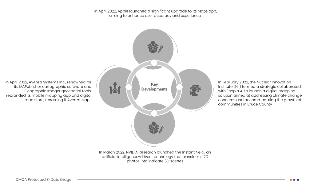
تطورات السوق
- في أبريل 2022، أجرت Apple تحديثًا جذريًا لتطبيق خرائطها لتحسين دقة المستخدم وتجربته. يضم التطبيق الآن العديد من الميزات، بما في ذلك معلومات مفصلة عن الطرق والمدن والمباني والمسطحات المائية والتكوينات الأرضية. وتشمل التحسينات الملحوظة إبراز المناطق التجارية، وتمثيلًا أكثر تفصيلًا للمساحات الخضراء، وإضافة مبانٍ ثلاثية الأبعاد، ومسارات طرق مميزة. كما يمكن للمستخدمين الآن الوصول مباشرةً إلى مداخل مراكز التسوق أو المتاجر عند التنقل عبر مواقف السيارات، مما يوفر تجربة تنقل أكثر شمولًا وسهولة في الاستخدام.
- في أبريل 2022، أعادت شركة أفينزا سيستمز، المعروفة ببرنامجها الخرائطي MAPublisher وأدواتها الجغرافية المكانية Geographic Imager، تسمية تطبيق الخرائط المحمول ومتجر الخرائط الرقمي الخاص بها، ليصبح اسم أفينزا مابس. تتماشى هذه الخطوة الاستراتيجية مع النمو المتسارع للشركة ورؤية علامتها التجارية المتطورة. تواصل أفينزا مابس، التي تحظى بالفعل بانتشار واسع في كل من الأسواق المهنية والترفيهية، توسيع حضورها العالمي. يمكن للمشتركين، بما في ذلك الشركات والأفراد، الاستفادة من المنصة لتعزيز الوعي بالموقع، وتحسين السلامة، والوصول إلى أدوات رسم الخرائط المتقدمة، مما يعزز من مكانة أفينزا مابس كحل خرائط متعدد الاستخدامات وقيّم.
- في مارس 2022، أطلقت NVIDIA Research تقنية Instant NeRF، وهي تقنية تعتمد على الذكاء الاصطناعي تُحوّل الصور ثنائية الأبعاد إلى مشاهد ثلاثية الأبعاد مُعقدة. تُمثل تقنية مجال الإشعاع العصبي (NeRF)، وخاصةً نسخة Instant NeRF، قفزة نوعية في السرعة، حيث تتجاوز سرعتها 1000 مرة في بعض الحالات. تعمل هذه التقنية بشكل يُشبه صورة الخريطة النقطية، حيث تكشف عن اتجاه الضوء المُشعّ من جسم أو مشهد. عُرضت تقنية Instant NeRF في فعالية NVIDIA GTC، حيث استعرضت قدراتها في إنشاء صور رمزية، وعرض مشاهد ثلاثية الأبعاد للمشاركين في مؤتمرات الفيديو، وإعادة بناء البيئات لخرائط رقمية ثلاثية الأبعاد. يُمثل هذا الابتكار إنجازًا بارزًا في الاستفادة من الذكاء الاصطناعي لتوفير تجارب بصرية غامرة.
- في فبراير 2022، أقام معهد الابتكار النووي (NII) تعاونًا استراتيجيًا مع شركة Ecopia AI لإطلاق حلٍّ لرسم الخرائط الرقمية لمعالجة مخاوف تغير المناخ ومواكبة نمو المجتمعات في مقاطعة بروس. ومن المتوقع أن تستفيد البلديات الأعضاء في مجلس الابتكار البلدي (MIC) وشركاؤها من أحدث التقنيات، بما في ذلك الذكاء الاصطناعي والتعلم الآلي والصور الجوية. ويهدف هذا التعاون إلى خلق منظورٍ مُناسبٍ لمقاطعة بروس في القرن الحادي والعشرين، مما يعزز الكفاءة ويدعم اتخاذ القرارات المستنيرة. وتؤكد هذه المبادرة على أهمية الأدوات المبتكرة في رصد الظروف البيئية وتغيراتها مع مرور الوقت لدعم النمو المستدام في المنطقة.
لمزيد من المعلومات التفصيلية حول تقرير سوق الخرائط الرقمية في جنوب شرق آسيا، انقر هنا - https://www.databridgemarketresearch.com/reports/south-east-asia-digital-map-market
