Global Geographic Information System Gis Software Market
Market Size in USD Billion
 USD
10.67 Billion
USD
21.11 Billion
2024
2032
USD
10.67 Billion
USD
21.11 Billion
2024
2032
| 2025 - 2032 | |
| USD 10.67 Billion | |
| USD 21.11 Billion | |
| % | |
|
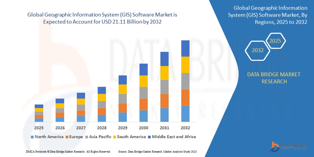
Geographic Information System (GIS) Software Market Size
- The global Geographic Information System (GIS) Software market size was valued at USD 10.67 Billion in 2024 and is expected to reach USD 21.11 Billion by 2032 at a CAGR of 8.9% during the forecast period
- The process of site selection land acquisition planning designing visualizing building project management operations and reporting are all aided by geographic information system (GIS) software for smart cities. The geographic information system (GIS) solutions are used in urban planning by experts to better properly analyze model and visualize places. By processing geospatial data from satellite imaging aerial photography and remote sensors geographic information system (GIS) software systems offer a comprehensive perspective of the land and infrastructure.
Geographic Information System (GIS) Software Market Analysis
- A software application called geographic information is used to evaluate produce maintain and map various sorts of data. By combining location data with various descriptive data types such as demographic data it also connects to the map. Analyzing interpreting and visualizing geographic data to identify trends patterns and relevant investments is now possible thanks to technology. Users can better understand relationships trends and spatial context via GIS. Recently mapping has become this technology's most significant role.
- The process of site selection land acquisition planning designing visualizing building project management operations and reporting are all aided by geographic information system (GIS) software for smart cities. The geographic information system (GIS) solutions are used in urban planning by experts to better properly analyze model and visualize places.
- North America dominates the Geographic Information System (GIS) Software market with the largest revenue share of 46.01% in 2025 driven by its advanced technological infrastructure widespread adoption of GIS applications in urban planning defense and environmental management and strong government support.
- Asia-Pacific is expected to be the fastest growing region in the Geographic Information System (GIS) Software market during the forecast period fueled by rapid urbanization increased investments in smart city projects and growing demand for location-based services across sectors like agriculture and transportation.
- The Software segment is expected to dominate the market with a market share of 74.6% owing to the rising adoption of cloud-based GIS solutions increasing integration with AI and IoT technologies and growing demand for spatial data analytics across industries..
Report Scope and Geographic Information System (GIS) Software Market Segmentation
|
Attributes |
Geographic Information System (GIS) Software Key Market Insights |
|
Segments Covered |
|
|
Countries Covered |
North America
Europe
Asia-Pacific
Middle East and Africa
South America
|
|
Key Market Players |
|
|
Market Opportunities |
|
|
Value Added Data Infosets |
In addition to the insights on market scenarios such as market value growth rate segmentation geographical coverage and major players the market reports curated by the Data Bridge Market Research also include import export analysis production capacity overview production consumption analysis price trend analysis climate change scenario supply chain analysis value chain analysis raw material/consumables overview vendor selection criteria PESTLE Analysis Porter Analysis and regulatory framework. |
Geographic Information System (GIS) Software Market Trends
“Increasing Integration of Artificial Intelligence in GIS”
- The integration of artificial intelligence (AI) in GIS software is transforming geospatial data analysis by enabling real-time processing, predictive modeling, and automated mapping. AI enhances spatial decision-making by identifying patterns, anomalies, and trends that would be difficult to detect manually.
- Companies like Esri and Trimble are leveraging AI in their GIS platforms to deliver smarter, more efficient geospatial solutions. For instance, Esri’s AI-enabled ArcGIS tools allow real-time object detection in satellite imagery, improving disaster response and urban planning accuracy.
- AI technologies are also enabling dynamic, real-time customization of GIS applications to suit specific user needs. This is particularly beneficial in urban development and infrastructure projects, where tailored mapping and simulations help planners make informed, data-driven decisions.
- Machine learning algorithms are increasingly being embedded in GIS software to analyze massive geospatial datasets and predict land-use changes, traffic congestion, or environmental risks. This predictive capability reduces manual data processing and enhances the precision of decision-making processes.
Geographic Information System (GIS) Software Market Dynamics
Driver
““Increasing Demand for Automation in Spatial Data Management”
- A major driver of the GIS software market is the rising demand for automation in spatial data collection, management, and analysis. Industries across sectors are investing in GIS to improve operational efficiency, accuracy, and data-driven decision-making.
- The integration of automation, AI, and machine learning with GIS platforms is revolutionizing how organizations visualize and analyze spatial information. For example, Hexagon AB uses automated GIS mapping for real-time infrastructure monitoring and urban development planning.
- GIS-based automation enables quicker environmental assessments, infrastructure modeling, and land-use planning. Municipal governments and transport authorities are automating these tasks to save time and improve accuracy in public service delivery.
- The increasing complexity of spatial data and the need for high-resolution analytics are boosting demand for advanced GIS platforms. Sectors like utilities and agriculture use GIS for precision asset tracking and resource allocation, reducing costs and improving service delivery.
- GIS solutions also contribute to sustainability goals by minimizing environmental impacts through efficient land and resource management. For instance, Trimble’s GIS solutions support smart irrigation and crop monitoring systems to reduce water waste and enhance agricultural productivity.
Restraint/Challenge
““High Upfront Cost and Integration Complexity”
- A significant restraint in the GIS software market is the high initial investment required for software licenses, specialized hardware, and skilled personnel. This barrier is particularly challenging for small and mid-sized organizations with limited IT budgets.
- For instance, small municipalities or local planning offices often struggle to afford the latest GIS platforms and ongoing software updates. Without sufficient funding, they may rely on outdated tools, reducing the accuracy and efficiency of spatial analysis.
- Integration with legacy IT systems remains a challenge, as many organizations face difficulties aligning GIS platforms with their existing data structures. This complexity can delay implementation and raise operational costs.
- The steep learning curve for GIS tools further complicates adoption. Organizations often need to invest in workforce training, which can temporarily affect productivity. For example, government departments implementing advanced GIS systems have reported delays due to extensive staff onboarding requirements.
- Additionally, data accuracy and standardization remain challenges. Disparate data sources and varying spatial formats often require significant preprocessing, which adds time and cost to GIS projects, especially in resource-constrained environments.
Geographic Information System (GIS) Software Market Scope
The market is segmented on the battery type component, function and end-user..
|
Segmentation |
Sub-Segmentation |
|
By Components |
|
|
By Function |
|
|
By End-User |
|
Geographic Information System (GIS) Software Market Scope
The market is segmented on the components organization size deployment type and industry vertical.
- By Components
On the basis of components, the Geographic Information System (GIS) Software market is segmented into Software, Hardware. The Software segment dominates the largest market revenue share of 74.6% in 2025. The software segment leads GIS market growth due to rising adoption of cloud-based GIS platforms, AI-driven geospatial analytics, and real-time data processing capabilities. Industries leverage these tools for smarter decision-making, infrastructure planning, and environmental monitoring, boosting efficiency and accuracy in spatial operations.
The Hardware segment is anticipated to witness the fastest growth rate of 18.7% from 2025 to 2032. GIS hardware, including GPS receivers, scanners, and drones, is essential for collecting high-quality geospatial data. Increasing use of mobile GIS devices and aerial mapping tools across sectors like defense, construction, and agriculture is driving demand for precise, durable, and field-ready hardware solutions.
- By Function
On the basis of function the Geographic Information System (GIS) Software market is segmented into mapping, surveying, telematics navigation, location based services. The mapping held the largest market revenue share in 2025.Mapping applications drive GIS market adoption by enabling detailed visual representation of spatial data for urban planning, disaster management, and environmental assessment. Governments and enterprises rely on GIS-based maps to optimize resource allocation, improve infrastructure, and make data-backed policy and business decisions.
The surveying segment is expected to witness the fastest CAGR from 2025 to 2032. Surveying remains a core GIS function, vital for land management, infrastructure development, and construction. Technological advancements like LiDAR integration and drone-based surveying are improving accuracy and reducing manual effort, expanding GIS adoption across engineering, real estate, and public works projects worldwide.
- By End User
On the basis of end user the Geographic Information System (GIS) Software market is segmented into agriculture, oil and gas, construction, mining, transportation, utilities, others. The agriculture held the largest market revenue share in 2025 and it is expected to witness the fastest CAGR from 2025 to 2032.. GIS in agriculture is revolutionizing precision farming by enabling real-time monitoring of soil health, crop patterns, and irrigation systems. Farmers use spatial data to optimize inputs, reduce waste, and boost yield, driving adoption of GIS tools in both commercial and small-scale farming.
Geographic Information System (GIS) Software Market Regional Analysis
- North America dominates the Geographic Information System (GIS) Software market with the largest revenue share of 46.01% in 2024 North America leads the GIS software market due to widespread adoption across government, environmental, and utility sectors. Investments in smart infrastructure, disaster management, and defense applications, along with robust tech ecosystems, drive continuous innovation and expansion in GIS technology deployment.
U.S. Geographic Information System (GIS) Software Market Insight
The U.S. Geographic Information System (GIS) Software market captured the largest revenue share of 71.2% within North America in 2025 The U.S. dominates the GIS market through federal investments in smart city programs, national security, and environmental monitoring. Agencies like FEMA and the USGS heavily rely on GIS, while private sectors use it for logistics, utilities, and real estate development.
Europe Geographic Information System (GIS) Software Market Insight
The Europe Geographic Information System (GIS) Software market is projected to expand at a substantial CAGR throughout the forecast period Europe’s GIS market is driven by urban digitization, transportation planning, and stringent environmental regulations. Integration of GIS in climate change modeling, energy efficiency projects, and public health initiatives supports regional demand, particularly in sustainability-focused infrastructure development and resource management.
Germany Geographic Information System (GIS) Software Market Insight
Germany is rapidly adopting GIS for urban mobility, utility planning, and environmental engineering. As a technology-driven economy, Germany emphasizes smart manufacturing and industrial mapping, integrating GIS with IoT and automation systems to enhance planning, monitoring, and operational efficiency.
France Geographic Information System (GIS) Software Market Insight
The France Geographic Information System (GIS) Software market is expected to expand at a considerable CAGR during the forecast period France’s GIS software market is growing due to investments in regional planning, smart city initiatives, and renewable energy management. Government support and academic collaborations promote spatial data.
Asia-Pacific Geographic Information System (GIS) Software Market Insight
The Asia-Pacific Geographic Information System (GIS) Software market is poised to grow at the fastest CAGR of over 25.1% in 2025 Asia-Pacific is the fastest-growing GIS market, fueled by rapid urbanization, infrastructure expansion, and increased demand for spatial intelligence. Government smart city initiatives, growing agriculture modernization, and technology integration in transportation and utilities boost regional GIS software adoption and innovation.
Japan Geographic Information System (GIS) Software Market Insight
Japan leverages GIS for earthquake preparedness, infrastructure monitoring, and population management. High urban density and aging infrastructure drive demand for geospatial analytics. GIS also supports precision agriculture and efficient logistics planning in Japan’s technologically advanced but resource-constrained environments.
China Geographic Information System (GIS) Software Market Insight
The China Geographic Information System (GIS) Software market accounted for the largest market revenue share in Asia Pacific in 2025 China’s GIS market is expanding due to large-scale investments in smart cities, environmental management, and national infrastructure projects. Government-led digital initiatives and rising private sector usage in agriculture, energy, and urban planning are accelerating adoption of domestic and international GIS platforms.
Geographic Information System (GIS) Software Market Share
The Geographic Information System (GIS) Software industry is primarily led by well-established companies including:
- Environmental Systems Research Institute Inc. (Esri) (U.S.)
- Hexagon (Sweden)
- Pitney Bowes Inc. (U.S.)
- Autodesk Inc. (U.S.)
- Trimble Inc. (U.S.)
- Topcon (Japan)
- Hi-Target. (China)
- BENTLEY SYSTEMS INCORPORATED (U.S.)
- Caliper Corporation (U.S.)
- Computer Aided Development Corporation Limited (Cadcorp) (U.K.)
- SuperMap Software Co. Ltd. (China)
- L3Harris Technologies Inc. (U.S.) and
- Maxar Technologies (U.S.).
Latest Developments in Global Geographic Information System (GIS) Software Market
- In July 2024, Esri and Trimble deepened their collaboration to enhance GIS and infrastructure management solutions. This initiative integrates Trimble's high-accuracy geospatial field systems with Esri's ArcGIS software, aiming to improve asset lifecycle management and support sustainable infrastructure planning.
- On October 15, 2024, Esri and Autodesk announced an enhanced integration, incorporating Esri's geospatial reference data into Autodesk Forma. This collaboration aims to transform early design and planning stages for architecture, engineering, construction, and operations professionals by providing cohesive spatial data and analytics
- In June 2022, Hexagon, a multibillion-dollar market leader in sensor, software, and digital reality solutions, is supporting start-ups to boost productivity and ESG. Hexagon Manufacturing Intelligence Division awarded SmartParts and RIIICO recognition. The manufacturing sector's efficiency and sustainability will rise thanks to the open innovation platform's assistance in scaling startups and expanding connectivity with top-tier businesses.
- In June 2022, Construct Helix was introduced by Bentley Acceleration Initiatives, the company's internal incubator for strategic investments. Bentley Systems is a provider of infrastructure engineering software. By offering SaaS solutions that will enable a connected data environment, it is specifically designed to digitalize the flow of construction project workflows.
SKU-
- Interactive Data Analysis Dashboard
- Company Analysis Dashboard for high growth potential opportunities
- Research Analyst Access for customization & queries
- Competitor Analysis with Interactive dashboard
- Latest News, Updates & Trend analysis
- Harness the Power of Benchmark Analysis for Comprehensive Competitor Tracking
Table of Content
1 INTRODUCTION
1.1 OBJECTIVES OF THE STUDY
1.2 MARKET DEFINITION
1.3 OVERVIEW OF GLOBAL GEOGRAPHIC INFORMATION SYSTEM (GIS) SOFTWARE MARKET
1.4 CURRENCY AND PRICING
1.5 LIMITATION
1.6 MARKETS COVERED
2 MARKET SEGMENTATION
2.1 KEY TAKEAWAYS
2.2 ARRIVING AT THE GLOBAL GEOGRAPHIC INFORMATION SYSTEM (GIS) SOFTWARE MARKET
2.2.1 VENDOR POSITIONING GRID
2.2.2 TECHNOLOGY LIFE LINE CURVE
2.2.3 MARKET GUIDE
2.2.4 COMPANY POSITIONING GRID
2.2.5 COMAPANY MARKET SHARE ANALYSIS
2.2.6 MULTIVARIATE MODELLING
2.2.7 TOP TO BOTTOM ANALYSIS
2.2.8 STANDARDS OF MEASUREMENT
2.2.9 VENDOR SHARE ANALYSIS
2.2.10 DATA POINTS FROM KEY PRIMARY INTERVIEWS
2.2.11 DATA POINTS FROM KEY SECONDARY DATABASES
2.3 GLOBAL GEOGRAPHIC INFORMATION SYSTEM (GIS) SOFTWARE MARKET: RESEARCH SNAPSHOT
2.4 ASSUMPTIONS
3 MARKET OVERVIEW AND INDUSTRY TRENDS
3.1 DRIVERS
3.2 RESTRAINTS
3.3 OPPORTUNITIES
3.4 CHALLENGES
4 EXECUTIVE SUMMARY
5 PREMIUM INSIGHT
5.1 TECHNOLOGICAL TRENDS
5.2 CASE STUDIES
5.3 PORTER ANALYSIS
5.4 VALUE CHAIN ANALYSIS
5.5 REGULATORY IMPLICATIONS
6 GLOBAL GEOGRAPHIC INFORMATION SYSTEM (GIS) SOFTWARE MARKET, BY FUNCTION
6.1 OVERVIEW
6.2 DATA IMPORT AND EXPORT
6.3 DATA VISUALIZATION
6.4 DATA MANAGEMENT
6.5 3D MODELLING
6.6 MAP CREATION
6.7 DATA ANALYSIS
6.7.1 BY TYPE
6.7.1.1. SPATIAL QUERYING
6.7.1.2. SPATIAL STATISTICS
6.7.1.3. NETWORK ANALYSIS
6.7.1.4. TERRAIN ANALYSIS
6.7.1.5. IMAGE ANALYSIS
6.7.1.6. 3D ANALYSIS
6.7.1.7. TEMPORAL ANALYSIS
6.8 GEOCODING
6.9 OTHERS
7 GLOBAL GEOGRAPHIC INFORMATION SYSTEM (GIS) SOFTWARE MARKET, BY DEPLOYMENT TYPE
7.1 OVERVIEW
7.2 DESKTOP GIS
7.3 MOBILE GIS
7.4 SERVER GIS
7.5 DEVELOPER GIS
7.6 ENTERPRISE GIS
7.7 OTHERS
8 GLOBAL GEOGRAPHIC INFORMATION SYSTEM (GIS) SOFTWARE MARKET, BY MODEL
8.1 OVERVIEW
8.2 STANDALONE
8.2.1 BY DEPLOYMENT TYPE
8.2.1.1. DESKTOP GIS
8.2.1.2. MOBILE GIS
8.2.1.3. SERVER GIS
8.2.1.4. DEVELOPER GIS
8.2.1.5. ENTERPRISE GIS
8.2.1.6. OTHERS
8.3 INTEGRATED
8.3.1 BY DEPLOYMENT TYPE
8.3.1.1. DESKTOP GIS
8.3.1.2. MOBILE GIS
8.3.1.3. SERVER GIS
8.3.1.4. DEVELOPER GIS
8.3.1.5. ENTERPRISE GIS
8.3.1.6. OTHERS
9 GLOBAL GEOGRAPHIC INFORMATION SYSTEM (GIS) SOFTWARE MARKET, BY DATA TYPE
9.1 OVERVIEW
9.2 VECTOR DATA
9.3 RASTER DATA
9.4 TABULAR DATA
9.5 3D DATA
9.6 TEMPORAL DATA
9.7 OTHERS
10 GLOBAL GEOGRAPHIC INFORMATION SYSTEM (GIS) SOFTWARE MARKET, BY APPLICATION
10.1 OVERVIEW
10.2 URBAN PLANNING
10.3 ENVIRONMENTAL MANAGEMENT
10.4 NATURAL RESOURCE MANAGEMENT
10.5 EMERGENCY RESPONSE
10.6 TRANSPORTATION PLANNING
10.7 MARKET ANALYSIS
11 GLOBAL GEOGRAPHIC INFORMATION SYSTEM (GIS) SOFTWARE MARKET, BY INDUSTRY
11.1 OVERVIEW
11.2 IT & TELECOM
11.2.1 BY FUNCTION
11.2.1.1. DATA IMPORT AND EXPORT
11.2.1.2. DATA VISUALIZATION
11.2.1.3. DATA MANAGEMENT
11.2.1.4. 3D MODELLING
11.2.1.5. MAP CREATION
11.2.1.6. DATA ANALYSIS
11.2.1.7. GEOCODING
11.2.1.8. OTHERS
11.3 ENERGY & UTILITIES
11.3.1 BY FUNCTION
11.3.1.1. DATA IMPORT AND EXPORT
11.3.1.2. DATA VISUALIZATION
11.3.1.3. DATA MANAGEMENT
11.3.1.4. 3D MODELLING
11.3.1.5. MAP CREATION
11.3.1.6. DATA ANALYSIS
11.3.1.7. GEOCODING
11.3.1.8. OTHERS
11.4 AEROSPACE & DEFENCE
11.4.1 BY FUNCTION
11.4.1.1. DATA IMPORT AND EXPORT
11.4.1.2. DATA VISUALIZATION
11.4.1.3. DATA MANAGEMENT
11.4.1.4. 3D MODELLING
11.4.1.5. MAP CREATION
11.4.1.6. DATA ANALYSIS
11.4.1.7. GEOCODING
11.4.1.8. OTHERS
11.5 OIL & GAS
11.5.1 BY FUNCTION
11.5.1.1. DATA IMPORT AND EXPORT
11.5.1.2. DATA VISUALIZATION
11.5.1.3. DATA MANAGEMENT
11.5.1.4. 3D MODELLING
11.5.1.5. MAP CREATION
11.5.1.6. DATA ANALYSIS
11.5.1.7. GEOCODING
11.5.1.8. OTHERS
11.6 GOVERNMENT
11.6.1 BY FUNCTION
11.6.1.1. DATA IMPORT AND EXPORT
11.6.1.2. DATA VISUALIZATION
11.6.1.3. DATA MANAGEMENT
11.6.1.4. 3D MODELLING
11.6.1.5. MAP CREATION
11.6.1.6. DATA ANALYSIS
11.6.1.7. GEOCODING
11.6.1.8. OTHERS
11.7 CONSTRUCTION & REAL ESTATE
11.7.1 BY FUNCTION
11.7.1.1. DATA IMPORT AND EXPORT
11.7.1.2. DATA VISUALIZATION
11.7.1.3. DATA MANAGEMENT
11.7.1.4. 3D MODELLING
11.7.1.5. MAP CREATION
11.7.1.6. DATA ANALYSIS
11.7.1.7. GEOCODING
11.7.1.8. OTHERS
11.8 MINING
11.8.1 BY FUNCTION
11.8.1.1. DATA IMPORT AND EXPORT
11.8.1.2. DATA VISUALIZATION
11.8.1.3. DATA MANAGEMENT
11.8.1.4. 3D MODELLING
11.8.1.5. MAP CREATION
11.8.1.6. DATA ANALYSIS
11.8.1.7. GEOCODING
11.8.1.8. OTHERS
11.9 AGRICULTURE
11.9.1 BY FUNCTION
11.9.1.1. DATA IMPORT AND EXPORT
11.9.1.2. DATA VISUALIZATION
11.9.1.3. DATA MANAGEMENT
11.9.1.4. 3D MODELLING
11.9.1.5. MAP CREATION
11.9.1.6. DATA ANALYSIS
11.9.1.7. GEOCODING
11.9.1.8. OTHERS
11.1 TRANSPORTATION
11.10.1 BY FUNCTION
11.10.1.1. DATA IMPORT AND EXPORT
11.10.1.2. DATA VISUALIZATION
11.10.1.3. DATA MANAGEMENT
11.10.1.4. 3D MODELLING
11.10.1.5. MAP CREATION
11.10.1.6. DATA ANALYSIS
11.10.1.7. GEOCODING
11.10.1.8. OTHERS
11.11 HEALTHCARE
11.11.1 BY FUNCTION
11.11.1.1. DATA IMPORT AND EXPORT
11.11.1.2. DATA VISUALIZATION
11.11.1.3. DATA MANAGEMENT
11.11.1.4. 3D MODELLING
11.11.1.5. MAP CREATION
11.11.1.6. DATA ANALYSIS
11.11.1.7. GEOCODING
11.11.1.8. OTHERS
11.12 RETAIL & ECOMMERCE
11.12.1 BY FUNCTION
11.12.1.1. DATA IMPORT AND EXPORT
11.12.1.2. DATA VISUALIZATION
11.12.1.3. DATA MANAGEMENT
11.12.1.4. 3D MODELLING
11.12.1.5. MAP CREATION
11.12.1.6. DATA ANALYSIS
11.12.1.7. GEOCODING
11.12.1.8. OTHERS
11.13 OTHERS
12 GLOBAL GEOGRAPHIC INFORMATION SYSTEM (GIS) SOFTWARE MARKET, BY GEOGRAPHY
12.1 GLOBAL GEOGRAPHIC INFORMATION SYSTEM (GIS) SOFTWARE MARKET, (ALL SEGMENTATION PROVIDED ABOVE IS REPRESENTED IN THIS CHAPTER BY COUNTRY)
12.1.1 NORTH AMERICA
12.1.1.1. U.S.
12.1.1.2. CANADA
12.1.1.3. MEXICO
12.1.2 EUROPE
12.1.2.1. GERMANY
12.1.2.2. U.K.
12.1.2.3. ITALY
12.1.2.4. FRANCE
12.1.2.5. SPAIN
12.1.2.6. SWITZERLAND
12.1.2.7. NETHERLANDS
12.1.2.8. BELGIUM
12.1.2.9. RUSSIA
12.1.2.10. DENMARK
12.1.2.11. SWEDEN
12.1.2.12. POLAND
12.1.2.13. TURKEY
12.1.2.14. FINLAND
12.1.2.15. NORWAY
12.1.2.16. REST OF EUROPE
12.1.3 ASIA PACIFIC
12.1.3.1. JAPAN
12.1.3.2. CHINA
12.1.3.3. SOUTH KOREA
12.1.3.4. INDIA
12.1.3.5. AUSTRALIA
12.1.3.6. SINGAPORE
12.1.3.7. THAILAND
12.1.3.8. INDONESIA
12.1.3.9. MALAYSIA
12.1.3.10. PHILIPPINES
12.1.3.11. NEW ZEALAND
12.1.3.12. VIETNAM
12.1.3.13. TAIWAN
12.1.3.14. REST OF ASIA-PACIFIC
12.1.4 SOUTH AMERICA
12.1.4.1. BRAZIL
12.1.4.2. ARGENTINA
12.1.4.3. REST OF SOUTH AMERICA
12.1.5 MIDDLE EAST AND AFRICA
12.1.5.1. SOUTH AFRICA
12.1.5.2. UAE
12.1.5.3. SAUDI ARABIA
12.1.5.4. EGYPT
12.1.5.5. OMAN
12.1.5.6. QATAR
12.1.5.7. KUWAIT
12.1.5.8. BAHRAIN
12.1.5.9. ISRAEL
12.1.5.10. REST OF MIDDLE EAST AND AFRICA
13 GLOBAL GEOGRAPHIC INFORMATION SYSTEM (GIS) SOFTWARE MARKET,COMPANY LANDSCAPE
13.1 COMPANY SHARE ANALYSIS: GLOBAL
13.2 COMPANY SHARE ANALYSIS: NORTH AMERICA
13.3 COMPANY SHARE ANALYSIS: EUROPE
13.4 COMPANY SHARE ANALYSIS: ASIA PACIFIC
13.5 MERGERS & ACQUISITIONS
13.6 NEW PRODUCT DEVELOPMENT AND APPROVALS
13.7 EXPANSIONS
13.8 REGULATORY CHANGES
13.9 PARTNERSHIP AND OTHER STRATEGIC DEVELOPMENTS
14 GLOBAL GEOGRAPHIC INFORMATION SYSTEM (GIS) SOFTWARE MARKET , SWOT & DBMR ANALYSIS
15 GLOBAL GEOGRAPHIC INFORMATION SYSTEM (GIS) SOFTWARE MARKET, COMPANY PROFILE
15.1 AUTODESK
15.1.1 COMPANY SNAPSHOT
15.1.2 REVENUE ANALYSIS
15.1.3 GEOGRAPHIC PRESENCE
15.1.4 PRODUCT PORTFOLIO
15.1.5 RECENT DEVELOPMENTS
15.2 ESRI
15.2.1 COMPANY SNAPSHOT
15.2.2 REVENUE ANALYSIS
15.2.3 GEOGRAPHIC PRESENCE
15.2.4 PRODUCT PORTFOLIO
15.2.5 RECENT DEVELOPMENTS
15.3 ARCGIS ONLINE
15.3.1 COMPANY SNAPSHOT
15.3.2 REVENUE ANALYSIS
15.3.3 GEOGRAPHIC PRESENCE
15.3.4 PRODUCT PORTFOLIO
15.3.5 RECENT DEVELOPMENTS
15.4 QGIS
15.4.1 COMPANY SNAPSHOT
15.4.2 REVENUE ANALYSIS
15.4.3 GEOGRAPHIC PRESENCE
15.4.4 PRODUCT PORTFOLIO
15.4.5 RECENT DEVELOPMENTS
15.5 BENTLEY MAP
15.5.1 COMPANY SNAPSHOT
15.5.2 REVENUE ANALYSIS
15.5.3 GEOGRAPHIC PRESENCE
15.5.4 PRODUCT PORTFOLIO
15.5.5 RECENT DEVELOPMENTS
15.6 INTERGRAPH GIS
15.6.1 COMPANY SNAPSHOT
15.6.2 REVENUE ANALYSIS
15.6.3 GEOGRAPHIC PRESENCE
15.6.4 PRODUCT PORTFOLIO
15.6.5 RECENT DEVELOPMENTS
15.7 GLOBAL MAPPER
15.7.1 COMPANY SNAPSHOT
15.7.2 REVENUE ANALYSIS
15.7.3 GEOGRAPHIC PRESENCE
15.7.4 PRODUCT PORTFOLIO
15.7.5 RECENT DEVELOPMENTS
15.8 SAFE SOFTWARE
15.8.1 COMPANY SNAPSHOT
15.8.2 REVENUE ANALYSIS
15.8.3 GEOGRAPHIC PRESENCE
15.8.4 PRODUCT PORTFOLIO
15.8.5 RECENT DEVELOPMENTS
15.9 MANIFOLD SYSTEM
15.9.1 COMPANY SNAPSHOT
15.9.2 REVENUE ANALYSIS
15.9.3 GEOGRAPHIC PRESENCE
15.9.4 PRODUCT PORTFOLIO
15.9.5 RECENT DEVELOPMENT
15.1 GEOMEDIA
15.10.1 COMPANY SNAPSHOT
15.10.2 REVENUE ANALYSIS
15.10.3 GEOGRAPHIC PRESENCE
15.10.4 PRODUCT PORTFOLIO
15.10.5 RECENT DEVELOPMENTS
15.11 SUPERGIS
15.11.1 COMPANY SNAPSHOT
15.11.2 REVENUE ANALYSIS
15.11.3 GEOGRAPHIC PRESENCE
15.11.4 PRODUCT PORTFOLIO
15.11.5 RECENT DEVELOPMENTS
15.12 CITYENGINE
15.12.1 COMPANY SNAPSHOT
15.12.2 REVENUE ANALYSIS
15.12.3 GEOGRAPHIC PRESENCE
15.12.4 PRODUCT PORTFOLIO
15.12.5 RECENT DEVELOPMENTS
15.13 OPENMAPTITLES
15.13.1 COMPANY SNAPSHOT
15.13.2 REVENUE ANALYSIS
15.13.3 GEOGRAPHIC PRESENCE
15.13.4 PRODUCT PORTFOLIO
15.13.5 RECENT DEVELOPMENTS
15.14 ENVI
15.14.1 COMPANY SNAPSHOT
15.14.2 REVENUE ANALYSIS
15.14.3 GEOGRAPHIC PRESENCE
15.14.4 PRODUCT PORTFOLIO
15.14.5 RECENT DEVELOPMENTS
15.15 HEXAGON GEOSPATIAL
15.15.1 COMPANY SNAPSHOT
15.15.2 REVENUE ANALYSIS
15.15.3 GEOGRAPHIC PRESENCE
15.15.4 PRODUCT PORTFOLIO
15.16 ARCGIS PRO
15.16.1 COMPANY SNAPSHOT
15.16.2 REVENUE ANALYSIS
15.16.3 GEOGRAPHIC PRESENCE
15.16.4 PRODUCT PORTFOLIO
15.16.5 RECENT DEVELOPMENTS
15.17 GEODA
15.17.1 COMPANY SNAPSHOT
15.17.2 REVENUE ANALYSIS
15.17.3 GEOGRAPHIC PRESENCE
15.17.4 PRODUCT PORTFOLIO
15.18 MAPINFO PROFESSIONAL
15.18.1 COMPANY SNAPSHOT
15.18.2 REVENUE ANALYSIS
15.18.3 GEOGRAPHIC PRESENCE
15.18.4 PRODUCT PORTFOLIO
15.19 GRASS GIS
15.19.1 COMPANY SNAPSHOT
15.19.2 REVENUE ANALYSIS
15.19.3 GEOGRAPHIC PRESENCE
15.19.4 PRODUCT PORTFOLIO
15.2 GEOSERVER
15.20.1 COMPANY SNAPSHOT
15.20.2 REVENUE ANALYSIS
15.20.3 GEOGRAPHIC PRESENCE
15.20.4 PRODUCT PORTFOLIO
15.21 GVSIG
15.21.1 COMPANY SNAPSHOT
15.21.2 REVENUE ANALYSIS
15.21.3 GEOGRAPHIC PRESENCE
15.21.4 PRODUCT PORTFOLIO
15.21.5 RECENT DEVELOPMENTS
15.22 GEOMEDIA SMART CLIENT
15.22.1 COMPANY SNAPSHOT
15.22.2 REVENUE ANALYSIS
15.22.3 GEOGRAPHIC PRESENCE
15.22.4 PRODUCT PORTFOLIO
15.22.5 RECENT DEVELOPMENTS
15.23 GEOPANDAS
15.23.1 COMPANY SNAPSHOT
15.23.2 REVENUE ANALYSIS
15.23.3 GEOGRAPHIC PRESENCE
15.23.4 PRODUCT PORTFOLIO
15.23.5 RECENT DEVELOPMENTS
15.24 MAPBOX
15.24.1 COMPANY SNAPSHOT
15.24.2 REVENUE ANALYSIS
15.24.3 GEOGRAPHIC PRESENCE
15.24.4 PRODUCT PORTFOLIO
15.24.5 RECENT DEVELOPMENTS
15.25 GOOGLE EARTH PRO
15.25.1 COMPANY SNAPSHOT
15.25.2 REVENUE ANALYSIS
15.25.3 GEOGRAPHIC PRESENCE
15.25.4 PRODUCT PORTFOLIO
15.26 GEODJANGO
15.26.1 COMPANY SNAPSHOT
15.26.2 REVENUE ANALYSIS
15.26.3 GEOGRAPHIC PRESENCE
15.26.4 PRODUCT PORTFOLIO
15.26.5 RECENT DEVELOPMENTS
15.27 ARC2EARTH
15.27.1 COMPANY SNAPSHOT
15.27.2 REVENUE ANALYSIS
15.27.3 GEOGRAPHIC PRESENCE
15.27.4 PRODUCT PORTFOLIO
15.28 GEONETWORK
15.28.1 COMPANY SNAPSHOT
15.28.2 REVENUE ANALYSIS
15.28.3 GEOGRAPHIC PRESENCE
15.28.4 PRODUCT PORTFOLIO
15.29 CARTO
15.29.1 COMPANY SNAPSHOT
15.29.2 REVENUE ANALYSIS
15.29.3 GEOGRAPHIC PRESENCE
15.29.4 PRODUCT PORTFOLIO
15.3 FME
15.30.1 COMPANY SNAPSHOT
15.30.2 REVENUE ANALYSIS
15.30.3 GEOGRAPHIC PRESENCE
15.30.4 PRODUCT PORTFOLIO
*NOTE: THE COMPANIES PROFILED IS NOT EXHAUSTIVE LIST AND IS AS PER OUR PREVIOUS CLIENT REQUIREMENT. WE PROFILE MORE THAN 100 COMPANIES IN OUR STUDY AND HENCE THE LIST OF COMPANIES CAN BE MODIFIED OR REPLACED ON REQUEST
16 CONCLUSION
17 RELATED REPORTS
18 ABOUT DATA BRIDGE MARKET RESEARCH
Data collection and base year analysis are done using data collection modules with large sample sizes. The stage includes obtaining market information or related data through various sources and strategies. It includes examining and planning all the data acquired from the past in advance. It likewise envelops the examination of information inconsistencies seen across different information sources. The market data is analysed and estimated using market statistical and coherent models. Also, market share analysis and key trend analysis are the major success factors in the market report. To know more, please request an analyst call or drop down your inquiry.
The key research methodology used by DBMR research team is data triangulation which involves data mining, analysis of the impact of data variables on the market and primary (industry expert) validation. Data models include Vendor Positioning Grid, Market Time Line Analysis, Market Overview and Guide, Company Positioning Grid, Patent Analysis, Pricing Analysis, Company Market Share Analysis, Standards of Measurement, Global versus Regional and Vendor Share Analysis. To know more about the research methodology, drop in an inquiry to speak to our industry experts.
Data Bridge Market Research is a leader in advanced formative research. We take pride in servicing our existing and new customers with data and analysis that match and suits their goal. The report can be customized to include price trend analysis of target brands understanding the market for additional countries (ask for the list of countries), clinical trial results data, literature review, refurbished market and product base analysis. Market analysis of target competitors can be analyzed from technology-based analysis to market portfolio strategies. We can add as many competitors that you require data about in the format and data style you are looking for. Our team of analysts can also provide you data in crude raw excel files pivot tables (Fact book) or can assist you in creating presentations from the data sets available in the report.