アジア太平洋地域の LiDAR 市場規模、シェア、トレンド分析レポート
Market Size in USD Billion
CAGR :
% 
 USD
938.74 Million
USD
4,432.53 Million
2024
2032
USD
938.74 Million
USD
4,432.53 Million
2024
2032
| 2025 –2032 | |
| USD 938.74 Million | |
| USD 4,432.53 Million | |
| % | |
アジア太平洋地域の LiDAR 市場のセグメンテーション、タイプ別 (固定 LiDAR と回転 LiDAR)、アプリケーション別 (自律走行車、航空検査、ロボット工学、測量とマッピング、林業と土地管理、再生可能エネルギー、その他) – 2032 年までの業界動向と予測
ライダー分析
LiDAR (光検出と測距) 分析では、レーザー光を使用して地球の表面までの距離を測定し、環境の高精度な 3D モデルを作成します。LiDAR システムはレーザー パルスを放射し、物体に反射してから戻ってくるまでの時間を測定します。このデータは、詳細な地形図の作成、植生の特定、インフラストラクチャのモデル化、環境の変化の監視に役立ちます。LiDAR は、林業、都市計画、考古学、災害管理などのアプリケーションで広く使用されています。反射信号を処理することで、LiDAR 分析は高解像度のポイント クラウドを生成します。これは、地形モデリング、等高線マッピング、植生分類に使用できます。
LiDAR市場規模
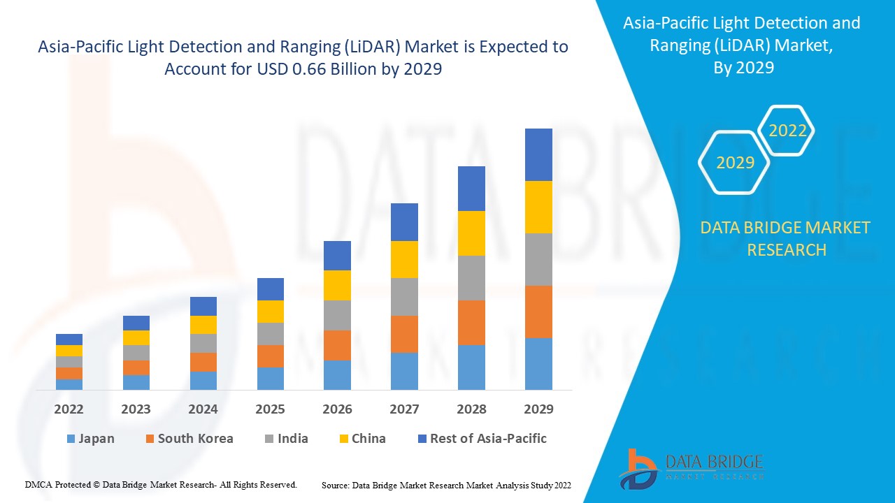
アジア太平洋地域の LiDAR 市場規模は 2024 年に 9 億 3,874 万米ドルと評価され、2025 年から 2032 年の予測期間中に 21.5% の CAGR で成長し、2032 年には 44 億 3,253 万米ドルに達すると予測されています。
LiDAR市場
「高精度な3Dマッピング技術の需要増加」
正確な 3D マッピング技術に対する需要の高まりは、アジア太平洋地域の LiDAR 市場における重要な推進力です。都市計画、建設、農業、環境モニタリングなどの業界では、意思決定と効率性を向上させるために正確な地形データが必要です。LiDAR は、地形、インフラストラクチャ、植生の詳細なマッピングを可能にする高解像度の 3D モデルを提供します。この技術は、精度が重要な洪水モデリング、自律走行車、地質調査などのアプリケーションに特に役立ちます。業界でデジタル ツイン技術とスマート シティ イニシアティブの採用が進むにつれて、正確で効率的な 3D マッピング ソリューションに対するニーズが高まり続け、LiDAR 市場の拡大を促進しています。
レポートの範囲と市場セグメンテーション
|
属性 |
LiDARの成分に関する主要な市場洞察 |
|
対象セグメント |
|
|
対象国 |
中国、日本、韓国、インド、タイ、マレーシア、インドネシア、ベトナム、台湾、フィリピン、シンガポール、オーストラリア、その他のアジア太平洋諸国。 |
|
主要な市場プレーヤー |
Innoviz Technologies Ltd (イスラエル)、SICK AG (ドイツ)、Hesai Group. (中国)、Cepton, Inc. (米国)、Génération Robots (フランス)、Aeva Inc. (米国)、AEye, Inc. (米国)、Trimble Inc. (米国) |
|
市場機会 |
|
|
付加価値データ情報セット |
Data Bridge Market Research がまとめた市場レポートには、市場価値、成長率、セグメンテーション、地理的範囲、主要プレーヤーなどの市場シナリオに関する洞察に加えて、輸出入分析、生産能力の概要、生産消費分析、価格動向分析、気候変動シナリオ、サプライ チェーン分析、バリュー チェーン分析、原材料/消耗品の概要、ベンダー選択基準、PESTLE 分析、ポーター分析、規制枠組みも含まれています。 |
LiDAR市場の定義
LiDAR (光検出と測距) は、レーザー パルスを使用して地球表面のセンサーと物体の間の距離を測定するリモート センシング技術です。高速レーザー ビームを発射し、パルスが反射するまでの時間を記録することで、LiDAR は高精度で詳細な 3D データを生成します。ポイント クラウドと呼ばれるこのデータは、地表の地形、植生、インフラストラクチャなどを正確に測定します。LiDAR は、陸上調査と航空調査の両方を含むさまざまな設定で高解像度の空間データを取得できるため、地図作成、林業、考古学、環境モニタリングなどの業界で広く使用されています。
LiDAR市場の動向
ドライバー
- 自動運転車の需要の高まり
自律走行車 (AV) の需要の高まりは、LiDAR 技術の採用拡大を推進する主な要因の 1 つです。LiDAR は、自動運転車が環境を正確に認識できるようにする上で重要な役割を果たしており、自律走行車システムに不可欠なコンポーネントとなっています。自動車業界が完全な自律輸送に向かって進む中、高解像度の 360 度 3D マッピングとリアルタイムの環境データを提供する LiDAR の能力は、安全性と信頼性を確保するために不可欠です。
LiDAR センサーはレーザー パルスを発して距離を測定し、周囲の正確な 3D マップを作成します。これにより、自律走行車は、暗い場所や悪天候などの厳しい状況でも、障害物、道路標識、歩行者、その他の車両を検出できます。このレベルの精度と奥行き認識により、自律システムは複雑な環境を安全にナビゲートできるため、LiDAR は自動運転車メーカーにとって好ましい選択肢となっています。従来のカメラ ベースまたはレーダー ベースのセンサーとは対照的に、LiDAR は動的環境で瞬時に判断を下すために不可欠な、より詳細で正確な空間情報を提供します。
自律走行車の需要の高まりも、LiDAR 技術の革新を後押ししています。自動車業界のニーズを満たすために、LiDAR システムのサイズ、コスト、複雑さの削減において大きな進歩がありました。たとえば、ソリッド ステート LiDAR は、従来の回転式 LiDAR システムよりも手頃で耐久性の高い代替手段であり、一般向け車両に広く採用されるために不可欠です。さらに、LiDAR とレーダーやカメラなどの他のセンサーとの統合の進歩により、自律システムのパフォーマンスが向上し、よりシームレスな操作が可能になっています。
アジア太平洋地域では、安全性、効率性、利便性の向上を背景に自動運転車への取り組みが強化されており、LiDAR テクノロジーは自動運転車開発の最前線に留まり、完全自動運転の交通手段の未来の実現を加速させるのに役立つでしょう。
例えば、
- 2024年10月、Mediumが公開した記事によると、LiDARの正確な3Dマップを作成し、リアルタイムで障害物を検出する機能は、自動運転車の安全な運行に不可欠である。自動運転車の技術が進歩するにつれて、LiDARはナビゲーション、意思決定、衝突回避に不可欠となり、完全自動運転の交通システムの重要な実現要因となる。
- 環境モニタリングとアプリケーションにおける LiDAR の利用増加
環境モニタリングやアプリケーションにおける LiDAR テクノロジの使用が増え、天然資源、生態系、環境リスクの理解と管理の方法が変わりつつあります。LiDAR は、非常に詳細で正確な 3D データをキャプチャできるため、森林管理、洪水モデリング、沿岸モニタリング、生息地マッピングなど、幅広い環境アプリケーションで非常に役立ちます。
環境モニタリングにおける LiDAR の最も重要な用途の 1 つは、森林管理です。LiDAR テクノロジにより、森林の樹冠、樹高、密度、バイオマスを正確にマッピングできるため、森林管理者は森林の健康状態を評価し、木材資源をより効果的に管理できます。LiDAR は、森林地帯の詳細な地形図を作成し、地滑りや浸食などの潜在的なリスクを特定したり、野生生物の生息地をマッピングして保護活動をサポートしたりするためにも使用できます。
洪水リスク管理において、LiDAR は正確な洪水モデルの作成に役立つ高解像度データを提供します。詳細な標高データを取得することで、科学者は LiDAR を利用して洪水パターンを予測し、潜在的な洪水地帯を評価し、洪水軽減戦略を策定できます。これは、従来の方法では正確なデータを取得するのが難しい複雑な地形の地域で特に役立ちます。
LiDAR is also increasingly used in coastal and marine studies. It can help map shorelines, monitor coastal erosion, and assess the health of marine ecosystems such as coral reefs. The ability to capture detailed data underwater and along coastlines is essential for understanding and protecting these vulnerable environments. Additionally, LiDAR is valuable in climate change research, helping to monitor environmental changes over time, such as ice melt in polar regions or deforestation in tropical forests.
As environmental concerns continue to grow, the ability of LiDAR to provide accurate, real-time data is crucial for monitoring, conserving, and managing the environment, making it an essential tool in sustainable resource management and environmental protection.
For instance,
- In April 2023, according to an article published by Neuvition, Inc., the growing use of LiDAR technology in environmental monitoring and management is highlighted. LiDAR's high-resolution 3D mapping enables detailed analysis of landscapes, vegetation, and topography, making it essential for tracking ecological health, detecting environmental changes, and managing natural resources, positioning it as a key tool for sustainable practices.
Opportunities
- Expanding Urbanization and Infrastructure Development Across the Globe
The accelerating trend of urbanization and infrastructure development across the globe presents a wealth of opportunities for the Asia-Pacific LiDAR (Light Detection and Ranging) market. As cities continue to grow, evolve, and modernize, the need for accurate, efficient, and scalable solutions to monitor and manage urban environments has never been greater. LiDAR technology, with its ability to capture high-resolution, three-dimensional data of landscapes, infrastructure, and buildings, is emerging as a key enabler in urban planning, construction, and infrastructure management.
As urbanization intensifies, cities are becoming more complex, with an increasing demand for smarter, more efficient solutions to tackle challenges like traffic congestion, waste management, and energy consumption. LiDAR technology plays a pivotal role in urban planning by providing highly detailed and accurate 3D models of cities. These models help urban planners visualize existing infrastructure, plan for new developments, and optimize the use of space. In the context of smart cities, LiDAR can assist in the creation of intelligent systems that monitor everything from transportation flows to public utilities, contributing to more sustainable and livable urban environments.
Infrastructure development is a crucial aspect of urbanization, with governments and private entities investing heavily in the construction and maintenance of roads, bridges, buildings, and utilities. LiDAR technology is indispensable in this regard, offering precise, high-resolution data for site surveys, topographic mapping, and structural inspections. LiDAR-equipped drones, for instance, can quickly and accurately map construction sites, allowing for more efficient project planning, reducing costs, and minimizing errors. Additionally, LiDAR’s ability to detect structural changes and potential hazards in existing infrastructure allows for proactive maintenance and repairs, ensuring that critical assets remain safe and functional.
As the demand for accurate, real-time data increases, the Asia-Pacific LiDAR market is expected to grow substantially. The integration of LiDAR with AI, machine learning, and autonomous technologies will further expand its applications, driving market adoption across sectors such as transportation, construction, and energy. This trend presents significant opportunities for companies providing LiDAR-based solutions, from hardware manufacturers to software developers.
For instance,
- In June 2024, according to an article by ResearchGate GmbH, LiDAR technology is used for urban geophysical surveys, such as mapping underground utilities and monitoring structural integrity. It helps in creating detailed 3D models of urban landscapes, which aid in infrastructure planning, flood modeling, and urban development, ensuring more accurate and efficient decision-making in city management
- Emergence of Drone-Based LiDAR
The emergence of drone-based LiDAR technology, coupled with the accelerating trends of urbanization and Asia-Pacific infrastructure development, has created immense opportunities for the Asia-Pacific LiDAR market. As cities expand and infrastructure projects grow in scale and complexity, the demand for precise, efficient, and cost-effective data collection solutions is increasing. Drone-based LiDAR is positioning itself as a transformative tool across various sectors, including infrastructure development, surveying, environmental monitoring, and agriculture.
In the rapidly developing Asia-Pacific infrastructure landscape, drone-based LiDAR plays a pivotal role by providing highly accurate, real-time 3D mapping. During construction, LiDAR-equipped drones can capture topographical data, ensuring that projects are planned with precision. This reduces the likelihood of errors during construction, optimizes material use, and helps adhere to strict timelines. Additionally, LiDAR drones support infrastructure monitoring by regularly scanning assets like roads, bridges, and pipelines. They can detect structural issues, such as cracks or deformations, before they become critical, enabling preventive maintenance and saving significant repair costs. In areas with complex or hard-to-reach infrastructure, drones make it possible to collect data quickly, minimizing the need for manual inspections.
LiDAR-equipped drones are also transforming traditional surveying methods. Land surveys that once took days or weeks can now be completed in a fraction of the time. Drones can cover vast areas, collecting precise data that would otherwise require extensive manpower and expensive equipment. For instance, in mining or construction, drones generate accurate 3D models for site planning and volume measurements, ensuring projects stay on track. In environmental monitoring, drone-based LiDAR allows for efficient tracking of changes in landscapes, such as erosion, deforestation, or land-use shifts. It also aids in flood risk assessments and conservation efforts by providing detailed elevation data, which is crucial for understanding water flow and ecosystem health.
In agriculture, drone-based LiDAR is revolutionizing land management. LiDAR-equipped drones help monitor crop health, assess irrigation needs, and detect early signs of pest infestations. The technology provides detailed, high-resolution data on soil topography and crop canopy structure, enabling farmers to make better-informed decisions and optimize their farming practices. LiDAR can also assist in precision agriculture by identifying the most efficient use of resources, reducing waste, and enhancing crop yields.
For instance,
- In August 2023, According to an article by MDPI, drone-based LiDAR is used for mapping and monitoring forest canopies, offering precise data on tree height, canopy structure, and vegetation density. This technology aids in ecological studies, forest management, and conservation efforts, providing critical insights into biodiversity, biomass estimation, and forest health
Restraints/Challenges
- High Costs of LiDAR Systems
The high costs of LiDAR (Light Detection and Ranging) systems are a significant barrier to their widespread adoption, despite their numerous applications in industries such as autonomous vehicles, construction, agriculture, and environmental monitoring. These systems are known for providing highly accurate, high-resolution 3D mapping, but their expense remains a challenge for many businesses and organizations seeking to incorporate LiDAR into their operations.
There are several reasons for the high costs associated with LiDAR systems. First, the technology itself requires specialized components such as laser scanners, GPS units, and high-performance sensors, which are expensive to manufacture. LiDAR sensors use advanced laser beams to measure distances and capture data, and the precision required for accurate results adds to the complexity of production. Additionally, the integration of these sensors with advanced software for data processing and analysis increases the overall system cost.
Second, the research and development (R&D) needed to improve LiDAR technology also contributes to its high price. Companies invest heavily in developing more compact, efficient, and accurate systems, which often requires significant upfront capital. While newer LiDAR technologies, such as solid-state LiDAR, are expected to drive down costs over time, the initial investment in cutting-edge technology remains high.
Furthermore, operational costs associated with LiDAR systems, such as training personnel to operate the equipment and processing the large amounts of data generated, add to the total expense. A single LiDAR scanning mission can generate terabytes of data, which requires specialized software and computing power for analysis, further driving up costs.
Despite these challenges, the prices of LiDAR systems are gradually decreasing as technological advancements make the components more affordable. As competition within the market increases and demand rises, it is expected that LiDAR will become more accessible, enabling broader use across industries.
For Instance
- In March 2022, according to a blog published by Queensland Drones, LiDAR mapping, while offering advantages over photogrammetry, remains expensive due to high equipment and software costs. UAV-mounted LiDAR systems cost around USD 2,500 per day, compared to USD 30,000 for manned aircraft systems
- Stringent Regulations for Drone-Based LiDAR Operations and Privacy Concerns
Material properties, particularly viscosity, play a crucial role in determining the efficiency and quality of the extrusion process. Viscosity, a measure of a material's resistance to flow, directly influences how materials behave under the high-pressure and high-temperature conditions typical of extrusion. Understanding and controlling viscosity is essential for optimizing the extrusion process, ensuring consistent product quality, and achieving desired mechanical properties.
In the context of polymer extrusion, viscosity affects the flow rate and uniformity of the molten material as it is forced through the die. Materials with high viscosity require greater force to push through the die, which can increase energy consumption and wear on the extrusion machinery. Conversely, materials with low viscosity flow more easily but may not provide the necessary structural integrity for certain applications. Therefore, achieving an optimal viscosity is critical for balancing processing efficiency and product performance.
The rheological behavior of materials, which includes viscosity, also impacts the thermal and mechanical properties of the extruded products. For instance, variations in viscosity can lead to inconsistent wall thickness, surface defects, and internal stresses within the extruded profiles. These defects can compromise the strength, durability, and aesthetic qualities of the final product. By precisely controlling the viscosity, manufacturers can enhance the dimensional accuracy and surface finish of the extruded materials, resulting in higher quality products.
Furthermore, viscosity influences the mixing and blending of additives and fillers within the base material. In applications where multiple components are combined to achieve specific properties, such as reinforced composites or multi-layered structures, the compatibility and dispersion of these components depend on the material's viscosity. Properly managed viscosity ensures a homogeneous mixture, preventing issues like phase separation or uneven distribution of fillers, which can degrade the material's overall performance.
Advanced extrusion technologies often incorporate real-time monitoring and control systems to manage viscosity and other critical parameters. These systems enable dynamic adjustments to processing conditions, such as temperature and screw speed, to maintain optimal viscosity throughout the extrusion process. This level of control enhances productivity, reduces material waste, and ensures consistent quality.
For instance,
- In July 2021, according to an article by Vidhi Centre, privacy concerns surrounding drone operations in India, highlighting the challenges of collecting sensitive data through aerial surveillance. It emphasizes the need for stricter regulations to protect individuals' privacy while balancing the benefits of drone technology, especially in sectors like mapping, agriculture, and infrastructure development
Impact and Current Market Scenario of Raw Material Shortage and Shipping Delays
Data Bridge Market Research offers a high-level analysis of the market and delivers information by keeping in account the impact and current market environment of raw material shortage and shipping delays. This translates into assessing strategic possibilities, creating effective action plans, and assisting businesses in making important decisions.
Apart from the standard report, we also offer in-depth analysis of the procurement level from forecasted shipping delays, distributor mapping by region, commodity analysis, production analysis, price mapping trends, sourcing, category performance analysis, supply chain risk management solutions, advanced benchmarking, and other services for procurement and strategic support.
Expected Impact of Economic Slowdown on the Pricing and Availability of Products
When economic activity slows, industries begin to suffer. The forecasted effects of the economic downturn on the pricing and accessibility of the products are taken into account in the market insight reports and intelligence services provided by DBMR. With this, our clients can typically keep one step ahead of their competitors, project their sales and revenue, and estimate their profit and loss expenditures.
LiDAR Market Scope
The market is segmented on the basis of type and application. The growth amongst these segments will help you analyze meagre growth segments in the industries and provide the users with a valuable market overview and market insights to help them make strategic decisions for identifying core market applications.
Type
- Fixed LiDAR
- Rotating LiDAR
- Other
Application
- Autonomous Vehicles
- Aerial Inspection
- Robotics
- Survey and Mapping
- Forestry and Land Management
- Renewable Energy
- Others
Asia-Pacific LiDAR Market Regional Analysis
The market is analyzed and market size insights and trends are provided by of type and application.
The countries covered in the market are China, Japan, South Korea, India, Thailand, Malaysia, Indonesia, Vietnam, Taiwan, Philippines, Singapore, Australia, rest of Asia-Pacific.
China dominates the Asia-Pacific LiDAR market due to advanced technological infrastructure, high adoption across industries like aerospace, defense, and automotive, and strong investments in autonomous vehicles and Geographic Information Systems (GIS).
Japan is emerging in the Asia-Pacific LiDAR Market due to rapid industrialization, increasing investments in smart cities, autonomous vehicles, infrastructure development, and growing demand for accurate mapping and environmental monitoring solutions.
The country section of the report also provides individual market impacting factors and changes in regulation in the market domestically that impacts the current and future trends of the market. Data points like down-stream and upstream value chain analysis, technical trends and porter's five forces analysis, case studies are some of the pointers used to forecast the market scenario for individual countries. Also, the presence and availability of regional brands and their challenges faced due to large or scarce competition from local and domestic brands, impact of domestic tariffs and trade routes are considered while providing forecast analysis of the country data.
Asia-Pacific LiDAR Market Share
The market competitive landscape provides details by competitors. Details included are company overview, company financials, revenue generated, market potential, investment in research and development, new market initiatives, regional presence, production sites and facilities, production capacities, company strengths and weaknesses, product launch, product width and breadth, application dominance. The above data points provided are only related to the companies' focus related to market.
Asia-Pacific LiDAR Market Leaders Operating in the Market Are:
- Innoviz Technologies Ltd (Israel)
- SICK AG (Germany)
- Hesai Group. (China)
- Cepton, Inc. (U.S.)
- Génération Robots (France)
- Aeva Inc. (U.S.)
- AEye, Inc. (U.S.)
- Trimble Inc. (U.S.)
Latest Developments in Asia-Pacific LiDAR Market
- In July 2024, Cepton, Inc. announced a definitive agreement to be acquired by Koito Manufacturing Co., Ltd., a long-time collaborator, and strategic partner. Following the completion of the acquisition, Cepton will operate as a privately held indirect subsidiary of Koito, maintaining its headquarters in San Jose, California. This partnership builds on their history of developing high-performance LiDAR solutions for automotive and smart infrastructure applications. The acquisition is expected to enhance LiDAR adoption in mass-market applications, leveraging Koito's manufacturing capabilities and Cepton's technological expertise
- In May 2024, Cepton, Inc. introduced StudioViz, a proprietary end-to-end LiDAR simulation platform, aimed at accelerating the development of advanced driver-assistance systems (ADAS) and autonomous vehicles (AVs). StudioViz enables OEMs and developers to simulate LiDAR integration scenarios, test sensor placements, and refine perception algorithms without the need for extensive physical testing. This tool provides high-fidelity 3D point cloud visualizations and scenario-building capabilities, reducing costs and complexity in real-world testing by recreating diverse environmental conditions virtually
- In June 2021, eledyne Optech and Teledyne CARIS, both Teledyne Technologies companies, have announced the launch of the next-generation bathymetric LiDAR, the CZMIL SuperNova. This innovative system offers unmatched depth performance and the highest green laser point density in its class, featuring SmartSpacing technology for efficient point distribution, real-time processing to reduce post-processing time, and configurable modes tailored for various water environments
- In November 2023, Aeva secured a production win with Nikon Corporation to supply its micron-precise LiDAR-on-Chip technology for Nikon's industrial metrology and quality control products. The multi-year agreement will integrate Aeva’s technology into Nikon’s automated inspection solutions for automotive, aerospace, and renewable energy sectors, with production starting in late 2024 and product availability in 2025
- 2024年6月、Innoviz Technologiesは大手OEMと提携し、レベル4(L4)自動運転車向けの新しい短距離LiDARソリューションを開発しました。このコラボレーションは、車両の近距離での環境認識能力を強化し、完全自動運転のためのより正確で信頼性の高いナビゲーションに貢献することに重点を置いています。
SKU-
世界初のマーケットインテリジェンスクラウドに関するレポートにオンラインでアクセスする
- インタラクティブなデータ分析ダッシュボード
- 成長の可能性が高い機会のための企業分析ダッシュボード
- カスタマイズとクエリのためのリサーチアナリストアクセス
- インタラクティブなダッシュボードによる競合分析
- 最新ニュース、更新情報、トレンド分析
- 包括的な競合追跡のためのベンチマーク分析のパワーを活用
目次
1 はじめに
1.1 研究の目的
1.2 市場の定義
1.3 概要
1.4 制限事項
1.5 対象市場
2 市場セグメンテーション
2.1 対象市場
2.2 地理的範囲
研究期間は2.3年と想定
2.4 通貨と価格
2.5 DBMR TRIPODデータ検証モデル
2.6 多変量モデリング
2.7 主要オピニオンリーダーとの一次インタビュー
2.8 DBMR市場ポジショングリッド
2.9 市場アプリケーションカバレッジグリッド
2.1 DBMRベンダーシェア分析
2.11 二次資料
2.12 仮定
3 エグゼクティブサマリー
4つのプレミアムインサイト
5 市場概要
5.1 ドライバー
5.1.1 LIDAR技術の継続的な革新と進歩
5.1.2 測量と地図作成の採用の増加
5.1.3 自動運転車の需要の増加
5.1.4 環境モニタリングとアプリケーションにおけるLIDARの利用増加
5.2 拘束
5.2.1 LIDARシステムの高コスト
5.2.2 代替技術との激しい競争
5.3 機会
5.3.1 世界規模での都市化とインフラ整備の拡大
5.3.2 ドローンベースLIDARの登場
5.3.3 LIDARとAIおよび機械学習の統合
5.4 課題
5.4.1 ドローンベースのLIDAR運用に対する厳格な規制とプライバシーの懸念
5.4.2 データ処理、管理、計算上の課題
6 アジア太平洋地域のLIDAR市場(タイプ別)
6.1 概要
6.2 固定ライダー
6.3 回転ライダー
7 アジア太平洋地域のLIDAR市場(アプリケーション別)
7.1 概要
7.2 自律走行車
7.3 航空検査
7.4 ロボット工学
7.5 調査と地図作成
7.6 林業と土地管理
7.7 再生可能エネルギー
7.8 その他
8 アジア太平洋地域のLIDAR市場(地域別)
8.1 アジア太平洋
8.1.1 中国
8.1.2 日本
8.1.3 韓国
8.1.4 インド
8.1.5 タイ
8.1.6 マレーシア
8.1.7 インドネシア
8.1.8 ベトナム
8.1.9 台湾
8.1.10 フィリピン
8.1.11 シンガポール
8.1.12 オーストラリア
8.1.13 その他のアジア太平洋地域
9 アジア太平洋地域のLIDAR市場:企業の状況
9.1 企業シェア分析:アジア太平洋地域
10 SWOT分析
11 社の企業プロフィール
11.1 テレダイン地理空間
11.1.1 会社概要
11.1.2 収益分析
11.1.3 企業株式分析
11.1.4 製品ポートフォリオ
11.1.5 最近の開発
11.2 トリンブル社
11.2.1 会社概要
11.2.2 収益分析
11.2.3 企業株式分析
11.2.4 製品ポートフォリオ
11.2.5 最近の開発
11.3 ジックAG
11.3.1 会社概要
11.3.2 企業株式分析
11.3.3 製品ポートフォリオ
11.3.4 最近の開発
11.4 河西グループ
11.4.1 会社概要
11.4.2 収益分析
11.4.3 企業株式分析
11.4.4 製品ポートフォリオ
11.4.5 最近の開発
11.5 AEVA株式会社
11.5.1 会社概要
11.5.2 収益分析
11.5.3 製品ポートフォリオ
11.5.4 最近の開発
11.6 株式会社エイアイ
11.6.1 会社概要
11.6.2 収益分析
11.6.3 製品ポートフォリオ
11.6.4 最近の開発
11.7 セプトン株式会社
11.7.1 会社概要
11.7.2 収益分析
11.7.3 製品ポートフォリオ
11.7.4 最近の開発
11.8 世代ロボット
11.8.1 会社のスナップショット
11.8.2 製品ポートフォリオ
11.8.3 最近の開発
11.9 イノビズテクノロジーズ株式会社
11.9.1 会社概要
11.9.2 収益分析
11.9.3 製品ポートフォリオ
11.9.4 最近の開発
11.1 クォンセナジーソリューションズ株式会社
11.10.1 会社概要
11.10.2 製品ポートフォリオ
11.10.3 最近の開発
12 アンケート
関連レポート13件
表のリスト
表1:アジア太平洋地域のLIDAR市場(タイプ別)、2018年~2032年(千米ドル)
表2:アジア太平洋地域の固定式ライダー市場における地域別市場規模(2018年~2032年、単位:千米ドル)
表3 アジア太平洋地域の回転型LIDAR市場、地域別、2018年~2032年(千米ドル)
表4 アジア太平洋地域のLIDAR市場、アプリケーション別、2024年、2018年~2032年(千米ドル)
表5:アジア太平洋地域のLIDAR市場における自動運転車市場(地域別、2018年~2032年)(単位:千米ドル)
表6:アジア太平洋地域のLIDAR航空検査市場(地域別)、2018年~2032年(千米ドル)
表7 アジア太平洋地域におけるLIDARロボット市場、地域別、2018年~2032年(千米ドル)
表8 アジア太平洋地域におけるLIDAR市場の調査とマッピング、地域別、2018年~2032年(千米ドル)
表9 アジア太平洋地域の林業・土地管理におけるLIDAR市場、地域別、2018年~2032年(千米ドル)
表10 アジア太平洋地域の再生可能エネルギーLIDAR市場(地域別、2018年~2032年)(単位:千米ドル)
表11 アジア太平洋地域のLIDAR市場におけるその他企業、地域別、2018年~2032年(千米ドル)
表12 アジア太平洋地域のLIDAR市場(国別、2018年~2032年)(単位:千米ドル)
表13 アジア太平洋地域のLIDAR市場(タイプ別)、2018年~2032年(千米ドル)
表14 アジア太平洋地域のLIDAR市場、用途別、2018年~2032年(千米ドル)
表15 中国LIDAR市場(タイプ別)、2018年~2032年(千米ドル)
表16 中国LIDAR市場、用途別、2018年~2032年(千米ドル)
表17 日本LIDAR市場(タイプ別)、2018年~2032年(千米ドル)
表18 日本LIDAR市場、用途別、2018年~2032年(千米ドル)
表19 韓国LIDAR市場(タイプ別)、2018年~2032年(千米ドル)
表20 韓国LIDAR市場(用途別)、2018年~2032年(千米ドル)
表21 インドLIDAR市場、タイプ別、2018年~2032年(千米ドル)
表22 インドLIDAR市場、用途別、2018年~2032年(千米ドル)
表23 タイのLIDAR市場(タイプ別)、2018年~2032年(千米ドル)
表24 タイのLIDAR市場、用途別、2018年~2032年(千米ドル)
表25 マレーシアLIDAR市場(タイプ別)、2018年~2032年(千米ドル)
表26 マレーシアLIDAR市場、用途別、2018年~2032年(千米ドル)
表27 インドネシアLIDAR市場、タイプ別、2018年~2032年(千米ドル)
表28 インドネシアLIDAR市場、用途別、2018年~2032年(千米ドル)
表29 ベトナムLIDAR市場、タイプ別、2018年~2032年(千米ドル)
表30 ベトナムLIDAR市場、用途別、2018年~2032年(千米ドル)
表31 台湾LIDAR市場(タイプ別)、2018年~2032年(千米ドル)
表32 台湾LIDAR市場、用途別、2018年~2032年(千米ドル)
表33 フィリピンLIDAR市場(タイプ別)、2018年~2032年(千米ドル)
表34 フィリピンLIDAR市場、用途別、2018年~2032年(千米ドル)
表35 シンガポールLIDAR市場、タイプ別、2018年~2032年(千米ドル)
表36 シンガポールLIDAR市場、用途別、2018年~2032年(千米ドル)
表37 オーストラリアLIDAR市場(タイプ別)、2018年~2032年(千米ドル)
表38 オーストラリアLIDAR市場、用途別、2018年~2032年(千米ドル)
表39 アジア太平洋地域のその他のLIDAR市場、タイプ別、2018年~2032年(千米ドル)
図表一覧
図1 アジア太平洋地域のLIDAR市場
図2 アジア太平洋地域のLIDAR市場:データの三角測量
図3 アジア太平洋地域のLIDAR市場:DROC分析
図4 アジア太平洋地域のLIDAR市場:アジア太平洋地域と地域市場の比較分析
図5 アジア太平洋地域のLIDAR市場:企業調査分析
図6 アジア太平洋地域のLIDAR市場:多変量モデリング
図7 アジア太平洋地域のLIDAR市場:インタビュー人口統計
図8 アジア太平洋LIDAR市場:DBMR市場ポジショングリッド
図9 アジア太平洋地域のLIDAR市場:市場アプリケーションカバレッジグリッド
図10 アジア太平洋地域のLIDAR市場:ベンダーシェア分析
図11 アジア太平洋地域のLIDAR市場:セグメンテーション
図12:アジア太平洋地域のLIDAR市場は2つのセグメントに分かれている(タイプ別)
図13 アジア太平洋地域のLIDAR市場:戦略的意思決定
図14 アジア太平洋LIDAR市場概要
図15:ライダー技術の継続的な革新と進歩が、予測期間中にアジア太平洋地域のライダー市場を牽引すると予想される
図16 固定式LIDARセグメントは、2025年と2032年にアジア太平洋LIDAR市場で最大のシェアを占めると予想されています。
図17 アジア太平洋地域のLIDAR市場の推進要因、制約要因、機会、課題
図18 アジア太平洋地域のLIDAR市場:タイプ別、2024年
図19 アジア太平洋地域のLIDAR市場:アプリケーション別、2024年
図20 アジア太平洋地域のLIDAR市場:スナップショット(2024年)
図21 アジア太平洋LIDAR市場:企業シェア2024年(%)
調査方法
データ収集と基準年分析は、大規模なサンプル サイズのデータ収集モジュールを使用して行われます。この段階では、さまざまなソースと戦略を通じて市場情報または関連データを取得します。過去に取得したすべてのデータを事前に調査および計画することも含まれます。また、さまざまな情報ソース間で見られる情報の不一致の調査も含まれます。市場データは、市場統計モデルと一貫性モデルを使用して分析および推定されます。また、市場シェア分析と主要トレンド分析は、市場レポートの主要な成功要因です。詳細については、アナリストへの電話をリクエストするか、お問い合わせをドロップダウンしてください。
DBMR 調査チームが使用する主要な調査方法は、データ マイニング、データ変数が市場に与える影響の分析、および一次 (業界の専門家) 検証を含むデータ三角測量です。データ モデルには、ベンダー ポジショニング グリッド、市場タイムライン分析、市場概要とガイド、企業ポジショニング グリッド、特許分析、価格分析、企業市場シェア分析、測定基準、グローバルと地域、ベンダー シェア分析が含まれます。調査方法について詳しくは、お問い合わせフォームから当社の業界専門家にご相談ください。
カスタマイズ可能
Data Bridge Market Research は、高度な形成的調査のリーダーです。当社は、既存および新規のお客様に、お客様の目標に合致し、それに適したデータと分析を提供することに誇りを持っています。レポートは、対象ブランドの価格動向分析、追加国の市場理解 (国のリストをお問い合わせください)、臨床試験結果データ、文献レビュー、リファービッシュ市場および製品ベース分析を含めるようにカスタマイズできます。対象競合他社の市場分析は、技術ベースの分析から市場ポートフォリオ戦略まで分析できます。必要な競合他社のデータを、必要な形式とデータ スタイルでいくつでも追加できます。当社のアナリスト チームは、粗い生の Excel ファイル ピボット テーブル (ファクト ブック) でデータを提供したり、レポートで利用可能なデータ セットからプレゼンテーションを作成するお手伝いをしたりすることもできます。